
Argyresthia ( Argyresthia ) brockeella
|
publication ID |
https://doi.org/10.5281/zenodo.827746 |
|
publication LSID |
lsid:zoobank.org:pub:48A417CD-CA76-4CA1-8E2C-93DE2E681CCC |
|
DOI |
https://doi.org/10.5281/zenodo.6051628 |
|
persistent identifier |
https://treatment.plazi.org/id/0389878F-9933-FFA9-FF6C-3087FDFB0ED4 |
|
treatment provided by |
Plazi |
|
scientific name |
Argyresthia ( Argyresthia ) brockeella |
| status |
|
44. Argyresthia ( Argyresthia) brockeella (Hübner, [1805])
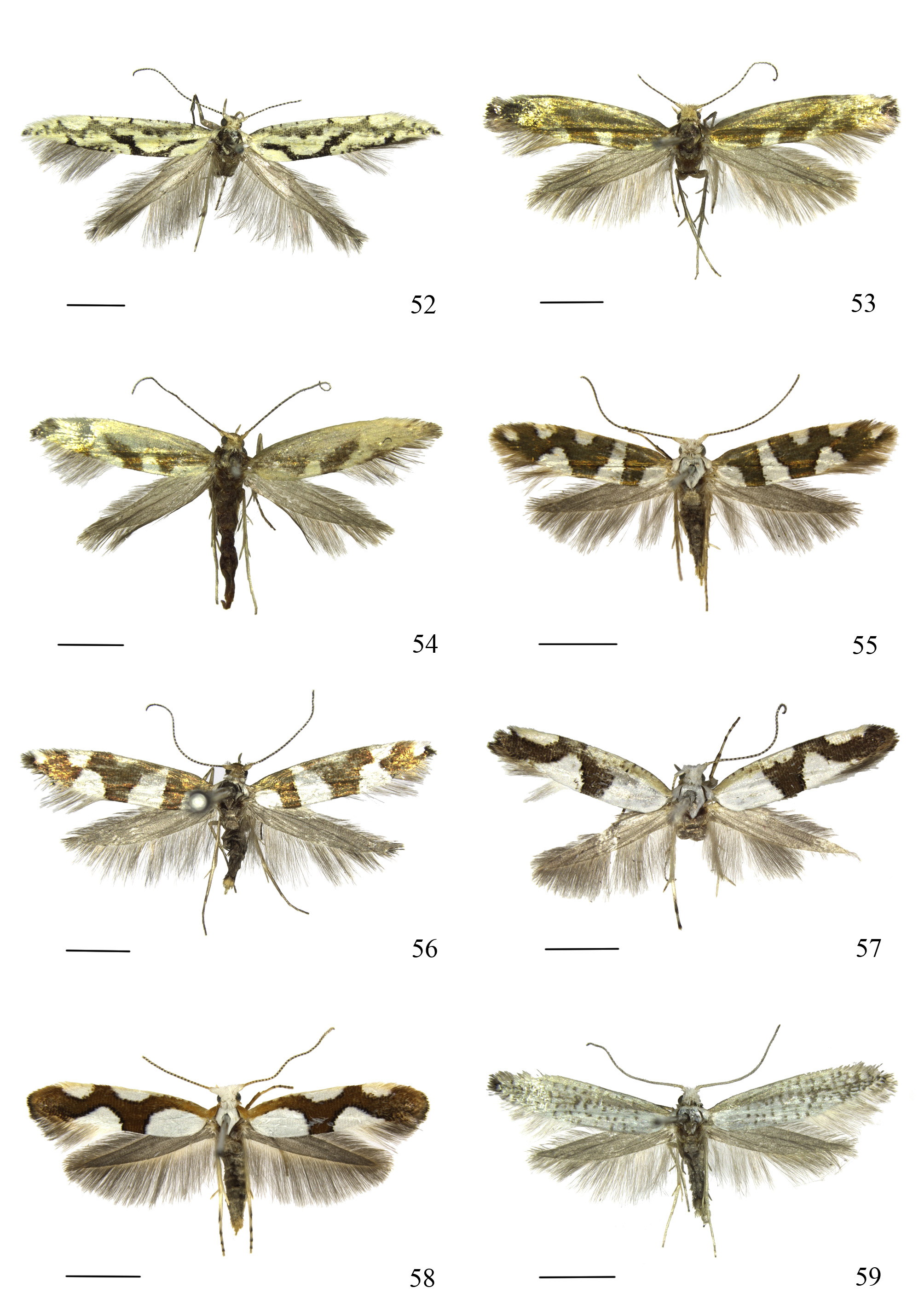
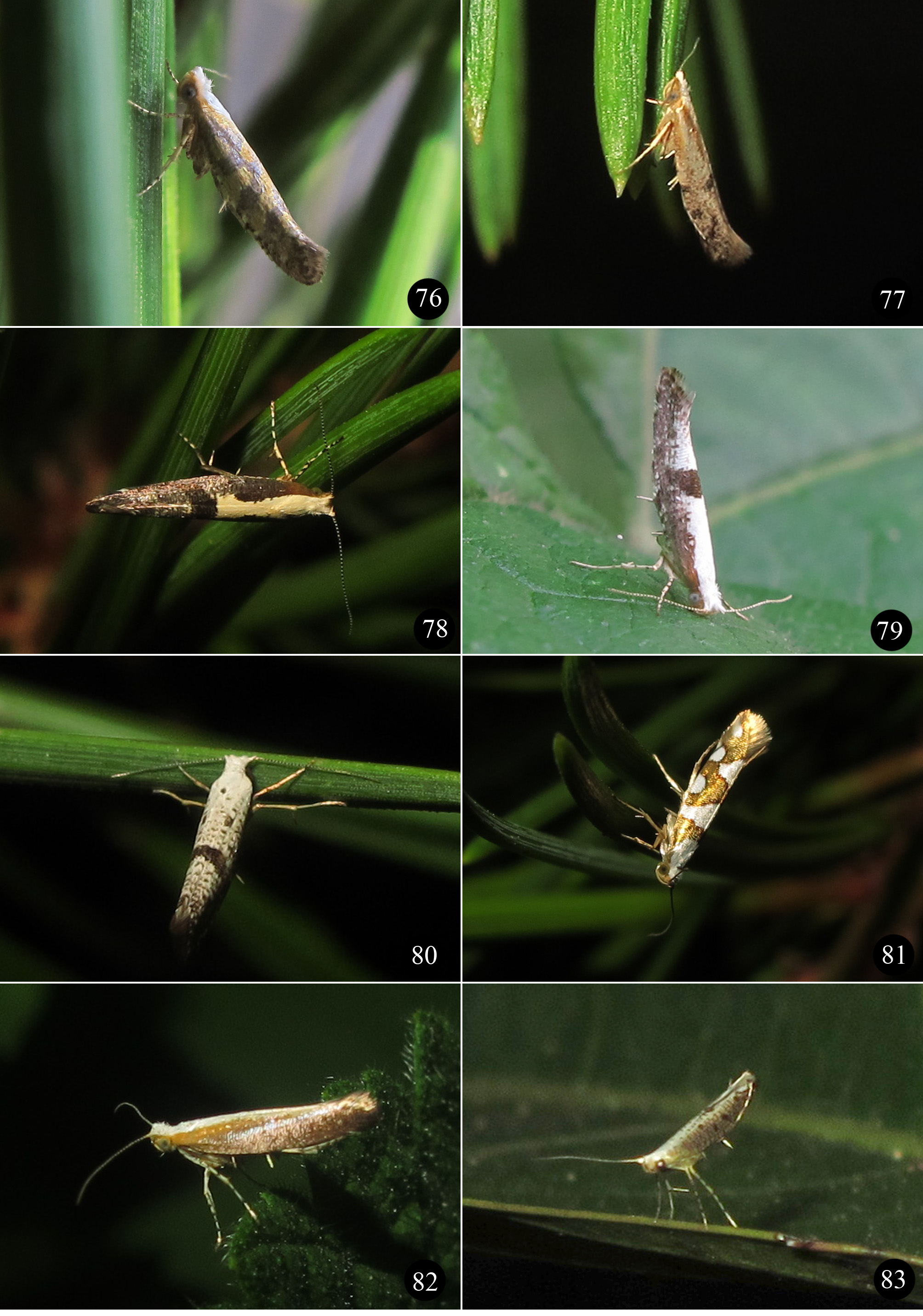
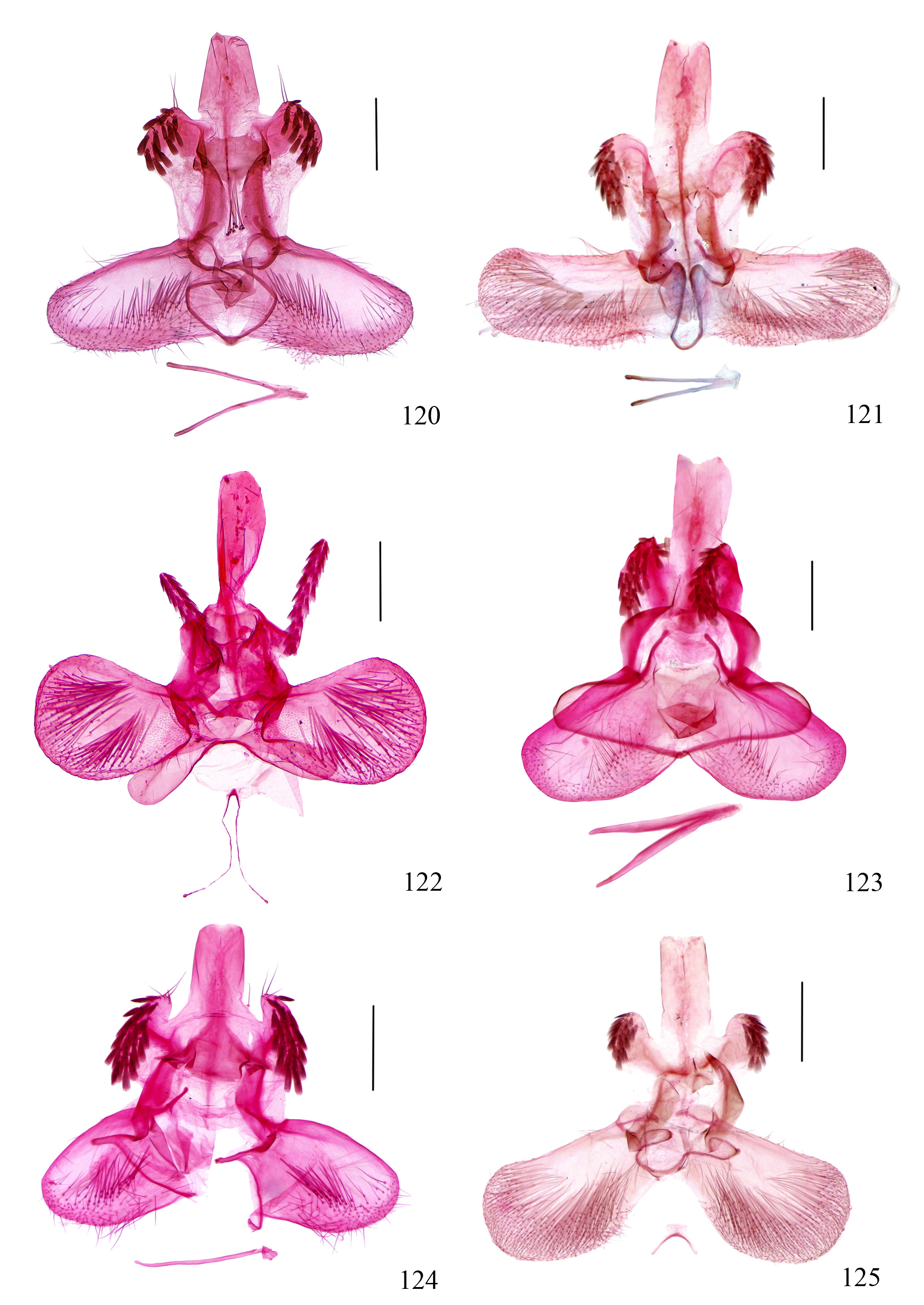
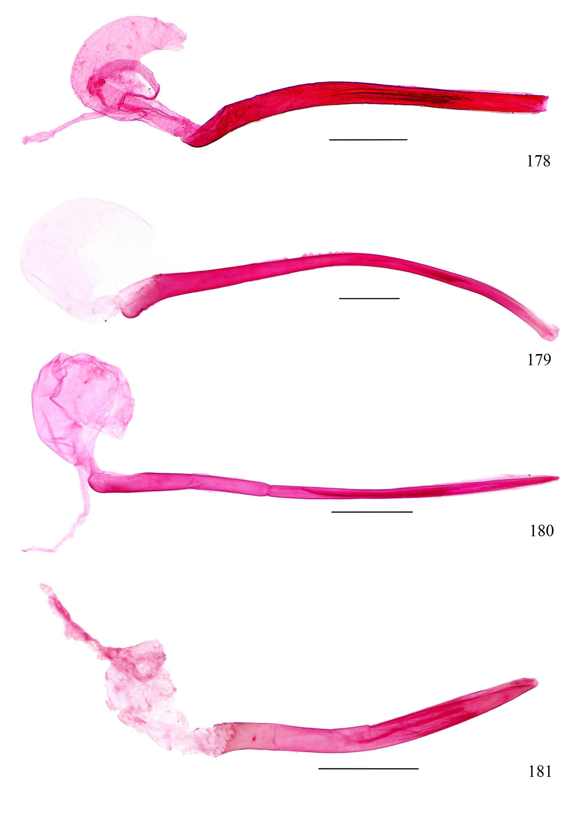
( Figs. 10 View FIGURES 9 – 10 , 55, 56 View FIGURES 52 – 59 , 81 View FIGURES 76 – 83 , 122 View FIGURES 120 – 125 , 178 View FIGURES 178 – 181 , 234 View FIGURES 233 – 244 , 280 View FIGURES 280 – 282 )
Tinea brockeella Hübner , [1813]: pl. 53, fig. 262. TL: Europe. TD: The type of brockeella was lost ( Moriuti 1977). Argyresthia brockeella (Hübner) : Hübner, 1825: 422; Jin & Wang, 2012: 235. Tinea View in CoL IW-ella Haworth, 1828: 569.
Tinea aurivittella Haworth, 1828: 570 .
Argyrosetia [ sic] IW-ella (Haworth): Stephens, 1829: 205.
Argyrosetia [ sic] auribittella (Haworth): Stephens, 1829: 205.
Oecophora brockeella (Hübner) : Treitschke, 1833: 164.
Argyresthia brockella (Hübner) : Stephens, 1835: 252. [misspelling] Oecophora debrockeel Duponchel, 1838: 464 .
Argyresthia fulguralis Matsumura, 1931: 1096 . TL: Japan (Sapporo, Hokkaidô). TD: HUIC. Argyresthia brockeella ab. aurivitella Gibeaux, 1983: 130.
Description. Adult ( Figs. 55, 56 View FIGURES 52 – 59 and 81 View FIGURES 76 – 83 ) wingspan 10.5̄12.0 mm.
Male genitalia: As in Figs. 122 View FIGURES 120 – 125 , 178 View FIGURES 178 – 181 and 234 View FIGURES 233 – 244 .
Female genitalia: As in Fig. 280 View FIGURES 280 – 282 .
Variation ( Fig. 56 View FIGURES 52 – 59 ): The forewing has the white dorsal fascia from before end of fold sharply narrowed or interrupted at anterior 2/5 from costa.
Material examined. Liaoning Province: 4Ƌ, 2♀, Laotudingzi ( 41.32°N, 124.90°E), Huanren City , 7̄ 9.viii.2009, leg. Weichun Li and Jiayu Liu GoogleMaps . Heilongjiang Province: 12Ƌ, 3♀, Yongan ( 52.38°N, 124.78°E), Tahe , 29.vii.2009, leg. Weichun Li and Jiayu Liu GoogleMaps ; 12♂ (1 without abdomen), 10♀, Liangshui National Nature Reserves ( 47.15°N, 128.87°E), Yichun City , 21̄ 22.vii.2009, leg. Weichun Li and Jiayu Liu GoogleMaps ; 2♂, Mt. Maoershan National Forest Park ( 42.85°N, 129.48°E), 18̄ 19.vii.2009, leg. Weichun Li and Jiayu Liu GoogleMaps ; 1♂, Mt. Lao ( 45.27°N, 127.61°E), Maoershan Town , Shangzhi County, 17.vii.2009, leg. Weichun Li and Jiayu Liu GoogleMaps ; 2♂, 2♀, Mt. Beishan ( 50.43°N, 124.14°E), Jiagedaqi District , 26̄ 7.vii.2009, leg. Weichun Li and Jiayu Liu GoogleMaps ; 1♀, Jiagedaqi District ( 50.43°N, 124.14°E), 14.vii.2012, leg. Dandan Zhang and Lijun Yang GoogleMaps ; 2♂, 3♀, Sanzhan ( 49.63°N, 126.81°E), Heihe City , 400 m, 27.vii.1997, leg GoogleMaps . Houhun Li. Jilin Province: 3Ƌ, 3♀, Huangsongpu Forest Farm ( 42.24°N, 128.18°E), Baihe Town , Erdao County, Yanbian City , 2, 4.vii.2009, leg. Weichun Li and Jiayu Liu GoogleMaps ; 9♂, 12♀, Huangsongpu Forest Farm ( 42.24°N, 128.18°E), Baihe Town , Erdao County, Yanbian City , 1010 m, leg. Aihuan Zhang GoogleMaps ; 2♂, Baihe Town ( 42.46°N, 128.15°E), Erdao County, Yanbian City , 730 m, 3.viii.2004, leg. Zhijie Wang GoogleMaps ; 1♂, Baihe Town ( 42.46°N, 128.15°E), Erdao County, Yanbian City , 760 m, 1.viii.2004, leg. Aihuan Zhang GoogleMaps ; 1♂, Mt. Changbai ( 42.03°N, 128.08°E), Yanbian City , 8.vii.2012, leg. Bingzhong Ren GoogleMaps ; 1♂, 1♀, Huangheni ( 45.43°N, 128.03°E), Yanbian City , 14, 16.viii.1993, leg. Beijiansuo GoogleMaps ; 1♀, Jilin, vii.1995, leg. Beijiansuo ; 1♀ (without abdomen and right forewing), Huinan County ( 42.69°N, 126.06°E), 8.vii.1991, leg. Beijiansuo GoogleMaps ; Hebei Province: 10Ƌ, 6♀, Mt. Wuling ( 40.61°N, 117.45°E), Xinglong County, 800 m, 14.viii.2010, leg. Aihuan Zhang and Hongmei Chen GoogleMaps ; 37♂, 26♀ (3 exs. without abdomen), Shuangyuanfeng ( 40.61°N, 117.45°E), Mt. Wuling , Xinglong County, 800 m, 15̄18, 20̄21, 26̄ 29.vii.2011, leg. Houhun Li and Yanpeng Cai, slide no. NKLTT 002 ♂ GoogleMaps ; 38♂ (3 ex. without abdomen), 50♀ (6 ex. without abdomen), Mt. Wuling ( 40.61°N, 117.45°E), Xinglong County, 800 m, 20̄21, 27̄ 28.vii.2009, leg. Aihuan Zhang and Xueling Tian, slide no. LTT12201W GoogleMaps ; 1♂, 1♀, Shuangyuanfeng ( 40.61°N, 117.45°E), Mt. Wuling , Xinglong County, 800 m, 4.ix.2011, leg. Qiang Gao GoogleMaps ; 1♀, Shuangyuanfeng ( 40.61°N, 117.45°E), Mt. Wuling , Xinglong County, 800 m, 11.viii.2011, leg. Houhun Li and Bingbing Hu GoogleMaps ; 1♂, 5♀, Mt. Wuling ( 40.61°N, 117.45°E), Xinglong County, 800 m, 28̄ 29.vii.2010, Aihuan Zhang and Xiaoyu Shi GoogleMaps ; 1♀, Mt. Wuling ( 40.61°N, 117.45°E), Xinglong County, 800 m, 27.vii.2009, Xueling Tian and Long Liao GoogleMaps ; 4♂, 1♀, Mt. Wuling ( 40.61°N, 117.45°E), Xinglong County, 800 m, 2̄ 3.vii.2009, leg. Qing Jin et al. GoogleMaps ; 1♀, Mt. Wuling ( 40.61°N, 117.45°E), Xinglong County, 1000 m, 16.vi.2014, leg. Shurong Liu et al. GoogleMaps ; 1♂, 5♀, Zhongguyuan ( 40.56°N, 117.50°E), Mt. Wuling , Xinglong County, 900 m, 31.vii.2000, leg. Yanli Du and Zhendong Li GoogleMaps ; 1♂, 4♀, Shangsi ( 39.99°N, 114.45°E), Xiaowutai , Wei County, 1200 m, 25̄ 26.vii.2000, leg. Yanli Du and Zhendong Li GoogleMaps ; 2Ƌ, 1♀, Chijiapu ( 39.99°N, 114.45°E), Xiaowutai , Wei County, 1200 m, 27.vii.2000, leg. Yanli Du and Zhendong Li GoogleMaps ; 1♀, Jinhekou ( 39.95°N, 114.96°E), Xiaowutai , Wei County, 1200 m, 24.vii.2000, leg. Yanli Du and Zhendong Li GoogleMaps ; 1♀, Mt. Jinge ( 40.91°N, 115.84°E), Chicheng County, 850 m, 20.vii.2001, leg. Yanli Du and Shulian Hao GoogleMaps ; 1♀, Xiaowutai ( 39.97°N, 114.81°E), Wei County, 1200 m, 23.viii.2005, leg. Xiaoyun Li GoogleMaps . Tianjin: 1Ƌ, Heishuihe ( 40.18°N, 117.55°E), Mt. Baxian , 600 m, 1.vii.2010, leg. Mingrui Zhang and Shurong Liu GoogleMaps . Beijing: 2Ƌ, 4♀ (1 ex. without abdomen), Xiaolongmen Forest Farm ( 39.97°N, 115.44°E), 1080 m, 18̄ 19.vii.2010, Aihuan Zhang and Hongmei Chen GoogleMaps ; 1♂, 1♀, Xiaolongmen Forest Farm ( 39.97°N, 115.44°E), 1080 m, 31.vii.2009, leg. Aihuan Zhang and Ping Liu GoogleMaps ; 1♂, 2♀, Xiaolongmen Forest Farm ( 39.97°N, 115.44°E), 1080 m, 18.vii.2010, leg. Aihuan Zhang and Kai Yang GoogleMaps ; 1♂, 1♀, Xiaolongmen Forest Farm ( 39.97°N, 115.44°E), 1080 m, 13.vii.2009, leg. Ping Liu and Xueling Tian GoogleMaps ; 1♂, 1♀, Dakezuang Village ( 40.48°N, 115.85°E), Mt Song , 1, 19.viii.2010, leg. Aihuan Zhang and Zheng Li GoogleMaps ; 2♀, Dakezuang Village ( 40.48°N, 115.85°E), Mt Song , 2.viii.2010, leg. Aihuan Zhang and Xiaoyu Shi GoogleMaps ; 2Ƌ, 3♀, Mt. Baihua ( 39.84°N, 115.59°E), Mentougou , 15̄ 16.vii.2010, [without collector] GoogleMaps . Henan Province: 3Ƌ (1 ex. without abdomen), 5♀, Mt. Baiyun ( 33.68°N, 111.85°E), Song County, 1580 m, 18, 20̄22, 24.vii.2002, leg. Xinpu Wang, slide nos. JQ07314 ♀, JQ07321Ƌ, JQ07336 ♀, JQ07345 ♀ GoogleMaps . Shanxi Province: 7Ƌ, 13♀, Mt. Mian ( 36.87°N, 111.99°E), Jiexiu County, 1370 m, 24̄25, 27̄ 29.vii.2013, leg. Tengteng Liu and Peixin Cong GoogleMaps ; 6♂, 13♀, Mt. Mian ( 36.87°N, 111.99°E), Jiexiu County, 1370 m, 14, 17̄18, 20.vii.2014, leg. Tengteng Liu, Meiqing Yang and Sihan Lu GoogleMaps ; 1♂, Dadian Forest Station ( 36.55°N, 111.21°E), Mt. Wulu, Linfen City , 1620 m, 19.vii.2013, leg. Tengteng Liu and Peixin Cong GoogleMaps ; 10♂, 6♀, Mt. Lingkong ( 36.61°N, 112.08°E), Qinyuan City , 1560 m, 24̄ 27.vii.2014, leg. Tengteng Liu, Meiqing Yang and Sihan Lu, slide nos. LTT12548 ♂ GoogleMaps , LTT12549♀; 1♀, Mt.
Lingkong ( 36.61°N, 112.08°E), Qinyuan County, 1560 m, 31.vii.2013, Tengteng Liu and Peixin Cong; 28♂ GoogleMaps , 19♀ (2 ex. without abdomen), Mt. Luyashan ( 38.67°N, 112.03°E), Ningwu County, 1450 m, 19̄20, 24.vii.2011, leg. Shulian Hao and Jiayu Liu, slide no. NKLTT 001 ♂ GoogleMaps ; 5♂, 7♀ (1 ex. without abdomen), Xiyao Village ( 38.67°N, 112.01°E), Ningwu County, 1475 m, 21.vii.2011, leg. Shulian Hao and Jiayu Liu GoogleMaps ; 4♀, Dahe Forest Farm ( 35.46°N, 111.94°E), Yicheng County, Linfen City , 1202 m, 24, 26.vii.2013, leg. Shulian Hao and Mingjing Li GoogleMaps ; 2♂, 2♀ (1 ex. without abdomen), Dahe Forest Farm ( 35.46°N, 111.94°E), Yicheng County, Linfen City , 1620 m, 13, 18.vii.2012, leg. Qiang Gao and Na Chen GoogleMaps ; 4♂, 2♀, Dongxia ( 35.82°N, 112.28°E), Xiachuan , Qinshui County, Jin City , 1620 m, 13, 18.vii.2012, leg. Qiang Gao and Na Chen; Inner Mongolia Autonomous Region: 3Ƌ GoogleMaps , 3♀, Mt. Daqing ( 40.84°N, 110.99°E), Tumotezuoqi , 1140 m, 12.viii.2002, leg. Dandan Zhang and Zhiqiang Li GoogleMaps ; 1♀, Mt. Dongmotianling ( 40.43°N, 112.10°E), Heilaoyao , Helingerer County, Huhehaote City , 1480 m, 12.viii.2007, leg. Houhun Li and A. Bidzilya, slide no. LTT12032. Ningxia Hui Autonomous Region: 9Ƌ (1 ex. without abdomen) GoogleMaps , 13♀, 1 ex. (without abdomen and hindwings), Qiuqianjian Forest Station ( 35.56°N, 106.44°E), Qiuqianjia Forest Farm, Mt Liupan , 1700 m, 2.vii.2007, leg. Shulian Hao and Zhiwei Zhang, slide nos. LTT12046 ♀ GoogleMaps , LTT12048̄9♂; 1♀, Qiuqianjia Forest Farm ( 35.56°N, 106.44°E), Mt. Liupan , 1700 m, 1.vii.2007, leg. Shulian Hao and Zhiwei Zhang GoogleMaps ; 9♂, 2♂ ( by net), 8♀, 3♀ ( by net), Xiaonanchuan plant garden ( 35.34°N, 106.31°E), Erlonghe Forest Farm, Mt. Liupan , 1900 m, 27̄ 28.vii.2008, leg. Shulian Hao and Zhiwei Zhang GoogleMaps ; 1♂, 1♀, Mt. Liupan plant garden ( 35.34°N, 106.31°E), 1900 m, 30.vi.2007, leg. Xinpu Wang GoogleMaps ; 2♂, Liandianxia ( 35.39°N, 106.29°E), Mt. Liupan , 2080 m, 27.vi.2007, leg. Xinpu Wang GoogleMaps ; 2♂, Dongshanpo Forest Farm ( 35.39°N, 106.35°E), Mt. Liupan , 2050, 7.vii.2008, leg. Shulian Hao and Zhiwei Zhang GoogleMaps ; 1♂, Hougou Forest Station ( 35.67°N, 106.32°E), Woyangchuan Forest Farm, Mt. Liupan , 1700 m, 3.vii.2008, leg. Shulian Hao and Zhiwei Zhang GoogleMaps ; 1♂, Fengtai Forest Farm ( 35.65°N, 106.17°E), Mt. Liupan , 2330 m, 11.vii.2008, leg. Shulian Hao and Zhiwei Zhang GoogleMaps ; 2♂, Lvyuan Forest Farm ( 35.39°N, 106.35°E), Mt. Liupan , 1600 m, 6.vii.2008, leg. Shulian Hao and Zhiwei Zhang GoogleMaps ; 1♂, 1♀, Guamagou Forest Station ( 35.86°N, 106.47°E), Guamagou Forest Farm, Mt. Liupan , 2100 m, 29.vi.2008, leg. Shulian Hao and Zhiwei Zhang GoogleMaps ; 1♂ (without abdomen), 2♀, Heshangpu Forest Farm ( 35.68°N, 106.25°E), Mt. Liupan , 2100 m, 9̄ 10.vii.2008, leg. Shulian Hao and Zhiwei Zhang GoogleMaps ; 1♀, Heshangpu ( 35.68°N, 106.25°E), Mt. Liupan , 18.vii.1983, [without collector] GoogleMaps ; 1♂, 8♀, Xiaonanchuan ( 35.35°N, 106.31°E), Jingyuan County, 2400 m, 8.viii.2000, leg. Houhun Li and Shuxia Wang. Gansu Province: 2Ƌ GoogleMaps , 1♀, Mt. Xinglong ( 35.80°N, 104.07°E), Yuzhong County, 2120 m, 30.vii, 4.viii.1993, leg. Houhun Li GoogleMaps ; 1♀, Dangchuan Forest Farm ( 34.34°N, 106.16°E), Tianshui City , 1342 m, 28.vii.2006, leg. Xinpu Wang and Xiangfeng Shi GoogleMaps . Qinghai Province: 1Ƌ, Huzhu ( 36.83°N, 101.95°E), Haidong City , 11.vii.1994, leg. Institute of forest sciences of Qinghai, slide no. L95461 View Materials GoogleMaps ; 1♀, Mengda ( 35.84°N, 102.49°E), Xunhua County, 2240 m, 15.vii.1995, leg. Hounhun Li and Shuxia Wang. Xizang Autonomous Region: 4Ƌ GoogleMaps , 4♀, Mt. Birishenshan ( 29.66°N, 94.38°E), Bayi Town , Linzhi County, 3240̄ 3245 m, 27̄ 28.vii.2010, leg. Houhun Li et al., slide no. LTT12725Ƌ. Shaanxi Province: 1Ƌ GoogleMaps , 1♀, Chengcheng City ( 35.20°N, 109.94°E), 1000 m, 20.ii.1996, leg. Shuxia Wang, slide no. JQ07313 ♂ GoogleMaps ; 3♂ (1 ex. without abdomen), 2♀, Xinjiashan Forest Farm ( 34.21°N, 106.61°E), Feng County, 1600 m, 9, 10, 13, 14.vii.1988, leg. Houhun Li, slide no. JQ07335 ♂ GoogleMaps ; 1♂, 2♀, Jiefangmen Village ( 33.86°N, 107.85°E), Houzhenzi , Zhouzhi County, 1750 m, 16, 20.vii.1987, leg. Houhun Li GoogleMaps ; 2♂, 3♀, Hemu Village ( 47.71°N, 86.87°E), Buerjin County, 1114 m, 23.vii.2007, leg. Xinpu Wang GoogleMaps ; 1♂, 1♀, Baihaba Village ( 48.53°N, 86.71°E), Habahe County, 1264 m, 27.vii.2007, leg GoogleMaps . Xinpu Wang. Sichuan Province: 9♂ , 3♀, Rize ( 33.12°N, 103.88°E), Jiuzhaigou , 2700 m, 13.viii.2002, leg. Shulian Hao GoogleMaps ; 2♀, Zezhawa ( 33.16°N, 103.92°E), Jiuzhaigou , 2400 m, 16.viii.2002, leg. Shulian Hao GoogleMaps ; 1♀, Wuxuhai ( 29.00°N, 101.51°E), Jiulong County, 2700 m, 6.vii.2012, leg. Jinwei Li GoogleMaps ; Yunnan Province: 1♀, Jinghong County ( 22.09°N, 100.90°E), 12̄ 13.ix.2008, [without collector] GoogleMaps ; 1♀, Linjiapu ( 25.29°N, 98.70°E), Tengchong City , 2144 m, 15.viii.2014, leg. Kaijian Teng, Shurong Liu and Hua Rong, slide no. LTT12554 GoogleMaps .
Host plants: Betula spp., Alnus glutinosa (Linn.) Gaertn. (Betulaceae) ( Agassiz 1996).
Distribution. China ( Beijing, Gansu, Hebei, Heilongjiang, Henan, Inner Mongolia, Jilin, Liaoning, Ningxia, Qinghai, Shaanxi, Shanxi, Sichuan, Tianjin, Yunnan, Xinjiang, Xizang), Europe, Russia, Japan, Korea.
Diagnosis. This species is most similar to A. ( A.) goedartella (Linnaeus, 1758) . In the male genitalia of A. ( A.) brockeella the valva are widest in the distal 2/9, and the saccus is nearly uniform in width and rounded apically ( Fig. 122 View FIGURES 120 – 125 ). In A. ( A.) goedartella the valva is widest at the base, and the saccus is narrowed distally to a narrowly rounded apex ( Agassiz 1996: 79, Pl. 10, fig. 13). The variation in forewing pattern of A. ( A.) brockeella and A. ( A.) goedartella are also similar, but the two species can be separated by the abovementioned genital features.
Remarks. The forewing color and patterns of both A. ( A.) brockeella and A. ( A.) goedartella vary within populations; both pale and dark forms occur in both species ( Agassiz 1996). Variation in forewing pattern for A. ( A.) brockeella is newly described here.


No known copyright restrictions apply. See Agosti, D., Egloff, W., 2009. Taxonomic information exchange and copyright: the Plazi approach. BMC Research Notes 2009, 2:53 for further explanation.
|
Kingdom |
|
|
Phylum |
|
|
Class |
|
|
Order |
|
|
SuperFamily |
Yponomeutoidea |
|
Family |
|
|
Genus |
|
|
SubGenus |
Argyresthia |
Argyresthia ( Argyresthia ) brockeella
| Liu, Tengteng, Wang, Shuxia & Li, Houhun 2017 |
Argyresthia fulguralis
| Matsumura 1931: 1096 |
Tinea aurivittella
| Haworth 1828: 570 |