
Hypostomus faveolus, Zawadzki & Birindelli & Lima, 2008
|
publication ID |
https://doi.org/10.1590/S1679-62252008000300012 |
|
DOI |
https://doi.org/10.5281/zenodo.17162022 |
|
persistent identifier |
https://treatment.plazi.org/id/039187CC-5C0F-BF2F-577D-A001AC71FD49 |
|
treatment provided by |
Carolina |
|
scientific name |
Hypostomus faveolus |
| status |
sp. nov. |
Hypostomus faveolus View in CoL , new species
Hypostomus sp. “Honeycomb-pleco” (L 037a): Glaser & Glaser, 1995: 22 (photo; “ Brazil ”).
Hypostomus sp. “Xingu-Hypostomus” (L 161): Glaser & Glaser, 1995: 63 (photo; “rio Xingu/ Brazil ”).
Hypostomus sp. Stawikowski, 1989: 458 (“L37”, photo 4; “rio Araguaia”); Melo et al., 2005: 100-101 (photo; Mato Grosso, rio da Mortes, tributary of the rio Araguaia); Stawikowski et al., 2004: 44 (L 37; “ Brasilien, Pará, rio Tocantins, rio Araguaia (nahe Marabá) und Maranhão, rio Lageado”).
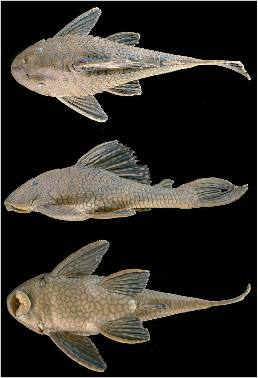
Holotype. MZUSP 90722 View Materials (206.0 mm SL), Brazil, Mato Grosso, Cocalinho, Corixo da Saudade ( Corixinho ), 25 km NO of Cocalinho on road MT 326, rio Araguaia drainage ( rio Tocantins basin), 14 o 17’20.6’’S 51 o 09’12.1’’W, 13 Oct 2004, J. L. O. Birindelli, O. Oyakawa, C. R. Moreira, M. I. Landim, A. C. Oliveira, A. Datovo, C. Nolasco. GoogleMaps
Paratypes. Brazil ( rio Tocantins basin ): MZUSP 86231 View Materials ( 1, 148.6 mm SL), collected with holotype. GoogleMaps MNRJ 25476 View Materials ( 1, 107.6 mm SL), Mato Grosso, Nova Xavantina, córrego Cachoeirinha , tributary of rio Pindaíba , 30 Jan 2002, P. A. Buckup et al. GoogleMaps MZUSP 4871 View Materials ( 2, 135.5- 158.3 mm SL), GoogleMaps ANSP 187418 About ANSP ( 1, 148.0 mm SL), Goiás, Aruanã, rio Araguaia , 14 o 54’S 51 o 05’W, Sep 1966, Excursão Depto. de Zoologia. GoogleMaps MZUSP 26534 View Materials ( 1, 170.0 mm SL), Goiás, rio Resende , tributary of rio Vermelho , ca. 10 km of Buenolândia, 15 o 48’S 50 o 17’W, Nov 1981, J. C. Garavello et al. GoogleMaps MZUSP 52128 View Materials ( 1, 180.7 mm SL), GoogleMaps INPA 28859 View Materials ( 1, 147.8 mm SL), Tocantins, Araguaçu, rio Água Fria , Fazenda Praia Alta 2 , road Araguaçu / Barreira do Piqui, 27 km N of Araguaçu, 12 o 44’S 49 o 56’W, 6 Jul 1997, F. C. T. Lima et al. GoogleMaps MZUSP 86790 View Materials ( 1, 77.1 mm SL), Mato Grosso, Canarana, rio Água Suja (or Curuá), tributary of rio das Mortes , on road BR 158, aproximately 13 km S of Serra Dourada, 13 o 49’47"S 52 o 02’15"W, Oct 2004, O. T. Oyakawa et al. GoogleMaps MZUSP 89041 View Materials ( 10, 23.8-39.8 mm SL), Goiás, Goiás, rio Vermelho 2 , on road GO 164, 15 o 54’11"S 50 o 06’55"W, 23 Jul 2005, C. Chamon et al. GoogleMaps MZUSP 89267 View Materials ( 4, 31.4-39.8 mm SL), Goiás, Crixás, rio Preto , on road GO 334 between Cocalinho and Nova Crixás, 14 o 22’18"S 50 o 39’13"W, 26 Jul 2005, C. Chamon et al. GoogleMaps MZUSP 89387 View Materials ( 8, 43.0- 145.3 mm SL), GoogleMaps NUP 5560 ( 1, 93.7 mm SL), Goiás, Crixás , Córrego da Taboca , tributary of rio Crixás-Mirim , on road GO 336, between Crixás and Nova Crixás, 14 o 19’27"S 50 o 12’32"W, 28 Jul 2005, C. Chamon et al. GoogleMaps MZUSP 89622 View Materials ( 1, 168.0 mm SL), Goiás, Luís Alves, rio Verde , tributary of rio Araguaia , 13 o 09’28"S 50 o 30’22"W, 10 Apr 2004, A. Akama. GoogleMaps MHNG 2691.077 View Materials ( 5, 53.5-81.3 mm SL), small tributary of rio Tocantins , N. Estreito (= “Paranadji”), 1993, U. Werner. GoogleMaps UNT 310 View Materials ( 3, 147.0-180.0 mm SL), Maranhão, Imperatriz, rio Mosquito , 5 o 32’S 47 o 29’W, 30 Jun 2000, NEAMB/UFT GoogleMaps .
Non-types. Brazil ( rio Tocantins basin ): LBP 1523 ( 7, 22.9-33.1 mm SL), Mato Grosso, Barra do Garça, rio Insula , tributary of rio das Mortes , 15º 40’57"S 52º 13’24"W, Dec 2002, C. Oliveira. GoogleMaps LBP 1839 ( 2, 36.9-67.5 mm SL), Mato Grosso, Barra do Garça, rio Insula , tributary to rio das Mortes , Araguaia , 15º32’54"S 52º12’17"W, Aug 2003, C. Martins et al. GoogleMaps MZUSP 19279 View Materials ( 1, 162.3 mm SL), rio Araguaia and Tocantins , Sudepe, 1975-1977. GoogleMaps MZUSP 22813 View Materials ( 1, 81.2 mm SL), Mato Grosso, Santa Terezinha, rio Araguaia , Oct 1964, H. A. Britski. GoogleMaps MZUSP 89076 View Materials ( 2, 52.4-83.4 mm SL), Goiás, Goiás, rio Bugre , tributary of rio Vermelho , on road GO 164, 25 km NW of Goiás, 15 o 47’13"S 50 o 07’53"W, 24 Jul 2005, C. Chamon et al. GoogleMaps MZUSP 89334 View Materials ( 2, 26.5-27.7 mm SL), Goiás, Nova Crixás, Córrego Pitomba , tributary of rio Crixás-Mirim , on road GO 336 near Nova Crixás, 14 o 08’35"S 50 o 20’13"W, 27 Jul 2005, C. Chamon et al. GoogleMaps MZUSP 89390 View Materials ( 3, 93.0- 113.9 mm SL), Goiás, Santa Terezinha de Goiás, rio Crixás-Açu , on road GO 465, 14 o 26’26"S 49 o 42’37"W, 28 Jul 2005, C. Chamon et al. GoogleMaps MZUSP 89482 View Materials ( 1, 44.0 mm SL), Goiás, Nova Crixás, rio Palmital , tributary of rio Crixás , on road GO 156, 13 o 46’28"S 50 o 16’00"W, 29 29 Jul 2005, C. Chamon et al. GoogleMaps MZUSP 90721 View Materials ( 1, 142.6 mm SL), Goiás, Crixás, ribeirão d’Anta , tributary of rio Crixás-Açu , on road GO 336, 14 o 32’06"S 50 o 02’12"W, Jul 2005, C. Chamon et al. GoogleMaps UNT 246 View Materials ( 2, 77.3-90.8 mm SL), Maranhão, Imperatriz, rio Mosquito , 5 o 32’S 47 o 29’W, NEAMB/UFT. GoogleMaps UNT 309 View Materials ( 1, 101.1 mm SL), Maranhão, Porto Franco, córrego Lajeado , 5 o 32’S 47 o 29’W, 28 Jun 2000, NEAMB/UFT. GoogleMaps UNT 312 View Materials (4, 97.1-142.9 mm SL), Maranhão, Porto Franco, ribeirão Sucupira , 6 o 22’S 47 o 27’W, 28 Jun 2000, NEAMB/ UFT. GoogleMaps UNT 325 View Materials ( 1, 67.3 mm SL), Maranhão, Ribamar Fiquene, ribeirão Sumaúma , 5 o 56’S 47 o 26’W, 28 Jun 2000, NEAMB/UFT. GoogleMaps UNT 326 View Materials ( 4, 27.5-48.8 mm SL), GoogleMaps UNT 1051 View Materials ( 5, 28.8-44.5 mm SL), GoogleMaps UNT 1115 View Materials ( 11, 15.5-113.5 mm SL), Tocantins, Guaraí, córrego Barreiro , 8 o 50’S 48 o 31’W, 26 Jun 2000, NEAMB/UFT. GoogleMaps UNT 366 View Materials ( 1, 96.6 mm SL), Goiás, UHE Serra da Mesa , 13 o 46’58"S 48 o 25’00"W, 6 Jun 1997, NEAMB/UFT. GoogleMaps UNT 391 View Materials ( 1, 146.9 mm SL), GoogleMaps UNT 392 View Materials ( 1, 149.4 mm SL), GoogleMaps UNT 393 View Materials ( 1, 140 mm SL), Tocantins, Paranã , rio Paranã , 12 o 30’S 48 o 12’W, 9 May 2001, NEAMB/UFT. GoogleMaps UNT 507 View Materials ( 1, 151.4 mm SL), Tocantins, Santa Fé do Araguaia, rio Araguaia , 6 o 53’S 49 o 08’W, 12 Oct 2003, NEAMB/ UFT. GoogleMaps UNT 508 View Materials ( 1, 84.2 mm SL), Tocantins, Araguaína, creek between Filadélfia and Araguaína, 7 o 25’S 47 o 35’W, 2 Nov 2003, NEAMB/UFT. GoogleMaps UNT 509 View Materials ( 1, 40.1 mm SL), Tocantins, Araguaína, creek between Filadélfia and Araguaína, on road BR153, 7 o 26’S 47 o 30’W, 2 Nov 2003, NEAMB/UFT GoogleMaps . UNT 1028 View Materials ( 8, 22.1-52.4 mm SL) , UNT 1041 View Materials ( 6, 31.3-69.7 mm SL) , UNT 3216 View Materials ( 14, 15.6- 74.3 mm SL), Tocantins, Tocantinópolis, córrego Tobasa , 6 o 19’S 47 o 26’W, 29 Jun 2000, NEAMB/UFT. GoogleMaps Brazil ( rio Xingu basin ): MNRJ 24823 View Materials ( 1, 28.7 mm SL), Mato Grosso, São José do Xingu, córrego do Moacir , tributary of ribeirão Capivara , tributary of rio Preto , rio Suiá-Miçu drainage , Jan 2006, P. Buckup et al GoogleMaps . MZUSP 34286 View Materials ( 2, 163.9- 177.4 mm SL) , ZMA 120.228 View Materials ( 1, 187.6 mm SL) , ZMA 120.129 View Materials ( 1, 175.2 mm SL), Mato Grosso, Gaúcha do Norte, confluence of the rios Culuene and Sete de Setembro , 12º56’S 52º49’W, 23 Aug 1984, M. Goulding. GoogleMaps MZUSP 76873 View Materials ( 3, 102.1- 140.2 mm SL), Mato Grosso, Paranatinga, Córrego Corgão , tributary of rio Culuene , km 65 of MT 130 from Paranatinga to Sorriso, 13 o 58’38"S 54 o 11’49"W, 24 Jan 2002, N. A. Menezes et al. GoogleMaps MZUSP 86851 View Materials ( 5, 44.4-66.0 mm SL), Mato Grosso, ribeirão Cascalheira , rio Turvo , tributary of rio Suiá-Miçu , aproximately 30 km N of Canarana, 13 o 13’28"S 51 o 55’50"W, 16 Oct 2004, O. T. Oyakawa et al. GoogleMaps MZUSP 86901 View Materials ( 1, 156.0 mm SL), Mato Grosso, Canarana, rio Coronel Vanick , tributary of rio Sete de Setembro , 58 km SO of Canarana, on road MT 120, 13 o 33’32"S 52 o 33’51"W, 18 Oct 2004, O. T. Oyakawa et al. GoogleMaps MZUSP 87012 View Materials ( 5, 119.0- 155.7 mm SL), Mato Grosso, Gaúcha do Norte, rio Culuene , 13 o 30’52"S 53 o 05’34"W, 19 Oct 2004, O. T. Oyakawa et al. GoogleMaps MZUSP 87043 View Materials ( 1, 64.7 mm SL), Mato Grosso, Gaúcha do Norte, rio Curisevo , Porto do Vitório, close to ribeirão Kevuaieli , 13 o 02’05"S 53 o 25’19"W, 19 Oct 2004, C. R. Moreira et al. GoogleMaps MZUSP 87078 View Materials ( 1, 108.3 mm SL), Mato Grosso, Gaúcha do Norte, rio Batovi ( Tamitatoala ), Fazenda Dois Netos in Salto da Alegria, 13 o 14’46"S 54 o 01’30"W, 21 Oct 2004, O. T. Oyakawa et al. GoogleMaps MZUSP 87092 View Materials ( 5, 56.0- 102.6 mm SL), Mato Grosso, Paranatinga, rio Jatobá , tributary of rio Ronuro , 12 o 49’19"S 54 o 09’24"W, 22 Oct 2004, O. T. Oyakawa et al. GoogleMaps MZUSP 89732 View Materials ( 5, 63.6-81.5 mm SL), Mato Grosso, Campinápolis, rio Culuene , between rapids and ribeirão Corgão , 13 o 49’S 53 o 15’W, 15 Jan 2006, A.Akama & J. L. O. Birindelli. GoogleMaps MZUSP 89747 View Materials ( 10, 34.7- 188.5 mm SL), Mato Grosso, Campinápolis, rio Culuene , at rapids (future area of PCH Paranatinga II ), 13 o 51’08"S 53 o 15’22"W, Jan 2006, A. Akama & J. L. O. Birindelli. GoogleMaps MZUSP 89797 View Materials ( 1, 53.4 mm SL), Mato Grosso, Campinápolis, rio Sucuri , tributary of the right margin of rio Culuene , close to its mouth, 13 o 55’40"S 53 o 17’10"W, Jan 2006, A. Akama & J. L. O. Birindelli. GoogleMaps MZUSP 91780 View Materials ( 1, 49.3 mm SL), Mato Grosso, Campinápolis, tributary of rio Culuene , 13 o 59’35"S 53 o 20’28"W, 21 Aug 2006, J. L. O. Birindelli et al. GoogleMaps MZUSP 91831 View Materials ( 3, 42.4-57.5 mm SL), Mato Grosso, Campinápolis, rio Sucuri , tributary of rio Culuene , 13 o 55’40"S 53 o 17’10"W, 21 Aug 2006, J. L. O. Birindelli et al. GoogleMaps MZUSP 91885 View Materials ( 3, 35.7-47.5 mm SL), Mato Grosso, Campinápolis, tributary of rio Culuene , 13 o 50’22"S 53 o 14’59"W, 21 Aug 2006, J. L. O. Birindelli et al. GoogleMaps MZUSP 91971 View Materials ( 14, 22.6-202.0 mm SL), Mato Grosso, Campinápolis, rio Culuene , in the rapids (future area of PCH Paranatinga II ), 13 o 51’08"S 53 o 15’22"W, 21 Aug 2006, J. L. O. Birindelli et al. GoogleMaps MZUSP 94133 View Materials ( 11, 92.0- 145.7 mm SL), Mato Grosso, Campinápolis, rio Culuene , 13 o 30’53"S 53 o 05’40"W, May 2007, F. C. T. Lima et al. GoogleMaps MZUSP 94193 View Materials ( 10, 24.0-110.0 mm SL), Mato Grosso, Campinápolis, rio Culuene , at PCH Paranatinga II , 13 o 49’S 53 o 15’W, May 2007, F. C. T. Lima et al. GoogleMaps MZUSP 94258 View Materials ( 1, 42.4 mm SL), Mato Grosso, Campinápolis, tributary of rio Culuene , 13 o 50’22"S 53 o 14’59"W, 20 May 2007, F. C. T. Lima et al. GoogleMaps MZUSP 94305 View Materials ( 3, 48.8-55.0 mm SL), Mato Grosso, Campinápolis, marginal lake of rio Culuene , 13 o 30’51"S 53 o 05’49"W, 22 May 2007, F. C. T. Lima et al. GoogleMaps MZUSP 94851 View Materials ( 73, 23.0-190.0 mm SL), Mato Grosso, Campinápolis, rio Culuene , cofferdam of PCH Paranatinga II , 13 o 49’00"S 53 o 15’00"W, 2 Jul 2007, L. M. Sousa et al. GoogleMaps MZUSP 98139 View Materials ( 6, 36.0-189.0 mm SL), Mato Grosso, Campinápolis, rio Culuene , Cachoeira do Adelino , 13º47’50"S 53º14’46"W, 2-14 Oct 2007, F. C. T. Lima et al. GoogleMaps Brazil ( upper rio Paraná basin ): NUP 5060 ( 3, 143.2- 174.8 mm SL), Goiás, Rochedo, rio Meia Ponte , tributary of rio Paranaíba , 17º27’35"S 49º15’43"W, May 2006, F. L. T. Garro et al. GoogleMaps
Diagnosis. Hypostomus faveolus is distinguished from its congeners by the unique combination of pale blotches over a darker background in body and fins ( vs. dark blotches over paler background in body and fins, in most congeners), and conspicuous keels on head, predorsal region and lateral plates ( vs. conspicuous keels absent in all remaining pale-spotted species of Hypostomus ). See Discussion for additional notes on its diagnosis.
Description. Standard length of 234 examined specimens 22.6 to 206.0 mm. Measurements of holotype and paratypes in Table 1 View Table 1 . Overall view of body in Figures 1 View Fig and 2 View Fig . Dorsal profile convex from snout tip to dorsal-fin origin and almost straight from that point to end of adipose fin, then concave to caudal fin. Ventral profile almost straight from snout tip to caudal fin. Caudal peduncle in cross-section from trapezoidal on its anterior portion to elliptical posteriorly, slightly flattened dorsally and ventrally. Body width at cleithral region greater than head depth. Head broad, narrow anteriorly, covered dorsolaterally with dermal ossifications, except for small naked area on snout tip. Median elongated bulge associated with mesethmoid usually conspicuous from snout tip to transverse line between nares. Eye dorsolateral. Interorbital space slightly concave in transversal section view due to supraorbital arching. Conspicuous ridge originating laterally to the nares, passing through supraorbital, and extending to posterior portion of pterotic-supracleitrum. Pterotic-supracleitrum not distinctly granular. Parieto-supraoccipital with conspicuous median ridge, and relatively well-developed posterior process bordered by single, wide plate. Oral disk longitudinally ellipsoidal. Lower lip not reaching transverse line between gill openings, its ventral surface covered with numerous papillae, decreasing in size posteriorly. Maxillary barbel moderately developed, about same size as orbital diameter (smaller than orbital diameter in specimens less than 100 mm SL). Mouth relatively small. Nineteen to 34 (mode 21, holotype 28) teeth in premaxilla, 21 to 35 (mode 29, holotype 28) teeth in dentary. Teeth long, moderately slender, bicuspid, and curved distally inward; mesial cusp with elongated crown and about twice length of lateral cusp, similar to Hypostomus aff. derbyi ( Muller & Weber, 1992: fig 2f). Dentary rami forming angle of approximately 90 o. Buccal papillae weakly to moderately developed.
Body covered with five lateral rows of moderately spinulose dermal plates. Dorsal-fin base naked. Predorsal region with two conspicuous keels, area between keels flat. Dorsal series of lateral plates with keel from first plate to azygous plate before adipose fin. Mid-dorsal series of lateral plates with keel interrupted between third and fourth plate by ventral extension of first plate of dorsal series. Median series of plates with weak keel and bearing lateral line. Mid-ventral series of plates with keel more developed from first to fifth or sixth plate. Ventral surface of head covered with minute scutelets, except for area dorsal to lower lip. Scutelets present in proximal portion of upper lip.Abdomen completely covered with minute scutelets in specimens larger than 110 mm SL, with exception of small areas around pectoral and pelvic fin origins and at urogenital opening. Preanal plate ranging from completely exposed to completely covered with skin. Twentyfive (34) or 26*(4) dorsal plates, 25(29) or 26*(9) mid-dorsal plates, 24(1), 25(8), 26*(27) or 27(2) median plates, 25(9), 26*(8) or 27(1) mid-ventral plates, 21(7), 22(21) or 23*(10) ventral plates. Three predorsal plates, eight plates below dorsal fin, six plates between dorsal fin and adipose fin.
Dorsal fin I,7, its origin situated approximately at midpoint between pectoral and pelvic fins, or slightly posterior to that point; its distal border convex. Last dorsal-fin ray reaching or almost reaching pre-adipose plate when adpressed. Adiposefin spine compressed and curved inward (spine more or less straight in specimens up to 70 mm SL). Pectoral fin I,6, its posterior border straight. Pectoral-fin spine slightly curved inward, covered with weak-developed odontodes, slightly more developed on its distal portion in larger specimens. Tip of adpressed pectoral fin reaching one-third of pelvic-fin spine length. Pelvic fin I,5, posterior border straight to slightly rounded. Pelvic-fin spine round in cross section, just surpassing anal-fin origin when adpressed. Anal fin I,4, tip reaching the fifth or sixth plate posterior to origin. Caudal-fin margin concave, 16 principal rays, inferior lobe longer than superior one.
Color in alcohol. Based only on specimens from the rio Tocantins basin. Dorsal and lateral surface of head and body with large, variously shaped but mainly rounded, paler blotches limited by narrow dark lines forming distinct net (or honeycomb) appearance ( Figs. 1 View Fig , 2 View Fig a-b). Blotches on head slightly smaller than those on body, and less distinct towards caudal peduncle. All fins usually with similar color pattern (distal margins of fins with faded blotches or completely dark in some specimens). Color pattern of ventral surfaces of head and body ranging from similar to that on dorsal and lateral surfaces to uniformly grey, without blotches. Some specimens ( e.g., MZUSP 87092, MZUSP 89390) showing two to five conspicuous oblique dark bars (called “stress coloration”; see picture in Glaser & Glaser, 1995: 63), first bar on posterior portion of head, originating at middle of orbit, second bar at first dorsal-fin branched rays, third bar at last dorsal-fin branched rays, fourth bar at adipose-fin and fifth at procurrent caudal-fin rays; these same specimens with pale band across interorbital area.
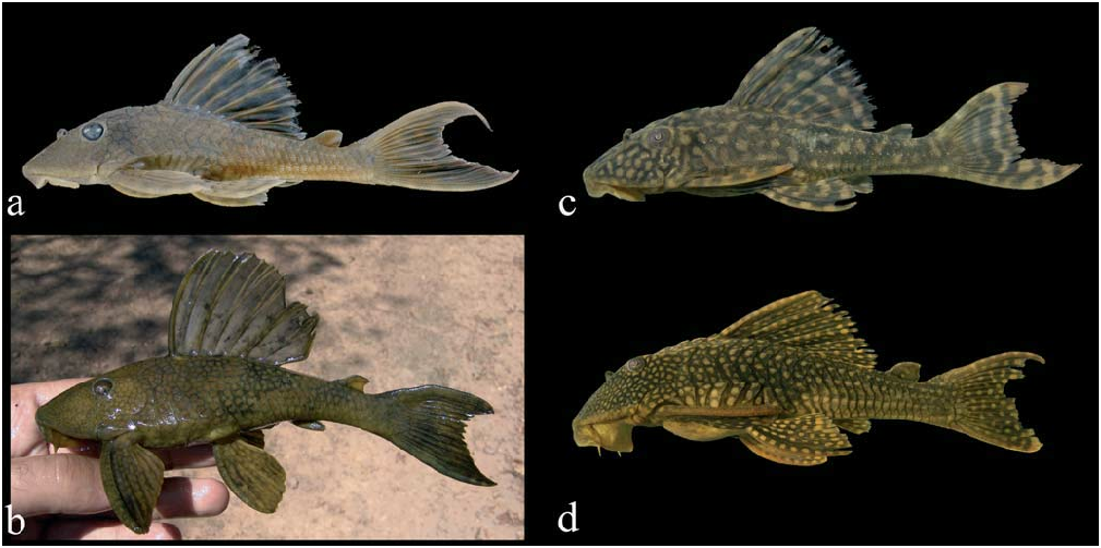
Color in life. Color pattern of living specimens similar to preserved specimens, but blotches more conspicuous and yellowish (see Figs. 2 View Fig a-c; Glaser & Glaser, 1995: 22, 63; Stawikowski et al., 2004: 44).
Geographical variation. In the majority of the specimens from the rio Xingu basin the dark limits of coloration are larger when compared to specimens of the rio Tocantins basin, and the limits between pale blotches are about same size or slightly larger than the blotches (compare Figs. 2 View Fig a-b to 2c-d). In addition, most small specimens (up to 50 mm SL) from the rio Xingu basin have pale blotches on the head forming vermiculations, whereas small specimens from the rio Tocantins basin show a pattern similar to that in adults. However, one lot of Hypostomus faveolus from the rio Suiá Miçu in the upper rio Xingu basin ( MZUSP 86851) shows a color pattern more similar to specimens from the rio Araguaia basin.
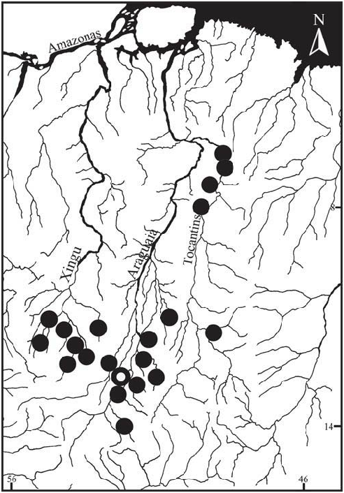
Distribution. Hypostomus faveolus is known from several localities in the rio Tocantins basin and the upper rio Xingu basin in central Brazil. There is a single record for the species at the rio Meia Ponte, a tributary of rio Paranaíba, upper rio Paraná drainage in central Brazil. The rio Meia Ponte has its headwaters at the divide with the rio Araguaia basin, which might suggest a faunal interchange between the river basins. However, it is a common practice among recreational fishermen and ranchers from Goiânia area (the capital of Goiás state) to release fishes from the rio Araguaia basin in artificial ponds in the rio Meia Ponte catchment area (A.P. Fialho and F. Tejerina-Garro, pers. comm.). The eventual rupture of those ponds might explain why this and other fish species from the rio Araguaia basin, such as Hyphessobrycon moniliger (Characidae) and Pterygoplichthys joselimaianus (Loricariidae) were recorded in the last few years in the rio Meia Ponte basin. We have not included this locality in the distribution map, since it likely represents an unnatural occurrence for the species ( Fig. 3 View Fig ).
Etymology. From the latin faveolus , after favus, honeycomb. In allusion to the color pattern formed by the pale blotches with thin dark limits. An adjective.
Ecological notes. Hypostomus faveolus is a eurytopic species, and has been collected both in rapids and slow flowing portions of middle to large rivers, both in rocky and soft substrates. A few juvenile specimens were collected in small streams and oxbow lakes in the rio Culuene basin.
| MZUSP |
Museu de Zoologia da Universidade de Sao Paulo |
No known copyright restrictions apply. See Agosti, D., Egloff, W., 2009. Taxonomic information exchange and copyright: the Plazi approach. BMC Research Notes 2009, 2:53 for further explanation.
|
Kingdom |
|
|
Phylum |
|
|
Class |
|
|
Order |
|
|
Family |
|
|
Genus |
Hypostomus faveolus
| Zawadzki, Cláudio H., Birindelli, José L. O. & Lima, Flávio C. T. 2008 |
Hypostomus sp.
| Glaser, U 1995: 22 |
Hypostomus sp.
| Glaser, U 1995: 63 |