
Lasiancistrus caucanus Eigenmann, 1912
|
publication ID |
https://doi.org/10.1590/S1679-62252005000400013 |
|
DOI |
https://doi.org/10.5281/zenodo.17094987 |
|
persistent identifier |
https://treatment.plazi.org/id/03921F68-FFF2-FF8B-9DE0-FF61FA7718B0 |
|
treatment provided by |
Carolina |
|
scientific name |
Lasiancistrus caucanus Eigenmann, 1912 |
| status |
|
Lasiancistrus caucanus Eigenmann, 1912 View in CoL
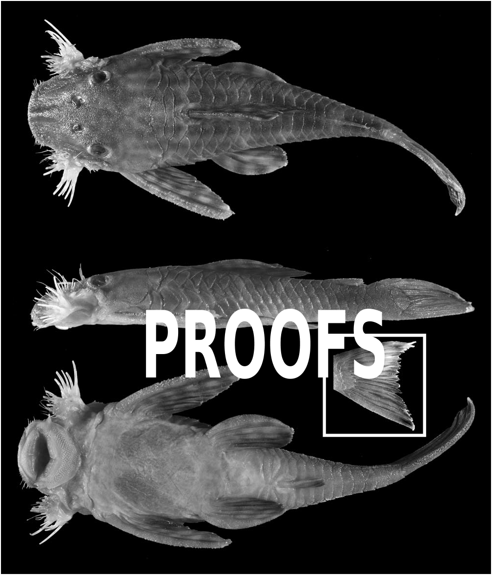
Fig. 4 View Fig
Lasiancistrus caucanus Eigenmann, 1912:11 View in CoL .Cartago, Colombia, C. H. Eigenmann, Jan-Mar 1912.
Hemiancistrus mayoloi Eigenmann, 1912:10 View in CoL . Río San Juan GoogleMaps , Ismina, Colombia, 5°11’N, 76°39’W.
Ancistrus planiceps Meek & Hildebrand, 1913:79 View in CoL . Río Tuyra, Boca de Cupe, Panama.
Lasiancistrus volcanensis Dahl, 1942: 83 View in CoL . Río Volcán near its junction to río San Bartolomé, tributary of río Magdalena, Antioquia Dep., Colombia.
Material Examined. Colombia. State not given: FMNH 56034 About FMNH , 1, 133.7 mm SL, holotype of L. caucanus , GoogleMaps and FMNH 56035 About FMNH , 4, 77.9- 132.9 mm SL, paratypes of L. caucanus, Cartago, Jan-Mar 1912 . GoogleMaps FMNH 56037 About FMNH , 2, 62.5-85.7 mm SL, paratypes of L. mayoloi, Istmina , 18 Mar 1912. GoogleMaps FMNH 58519 About FMNH , 1, 105.4 mm SL, Piedra Moler , 21 Feb 1912. GoogleMaps FMNH 58560 About FMNH , 1, 54.3 mm SL, Paila , 1913. GoogleMaps FMNH 58561 About FMNH , 0, Bernal Creek near Honda, 1913. GoogleMaps FMNH 76219 About FMNH , 1, 79.7 mm SL, no locality. GoogleMaps USNM 120723 About USNM , 1, 57.6 m SL, río Ariguanicito tributary of río Cesar , 24 Mar 1942. GoogleMaps USNM 308485 About USNM , 1, 52.4 mm SL, río Salado , 4 miles above confluence with río Truando , 15 Mar 1967. GoogleMaps USNM 175318 About USNM , 2, 75.7-91.9 mm SL, Batatal, río Ure , San Jorge, 23 Dec 1950. GoogleMaps Valle del Cauca, río Cauca - río Magdalena drainage : MCZ 35812 , 1, 80.4 mm SL, upper río Cauca and tributaries, Oct 1942. GoogleMaps MCZ 35871 , 1, 44.5 mm SL, upper Cauca, río Frío , 18 Oct 1942. GoogleMaps USNM 120155 About USNM , 1, 73.5 mm SL, upper Cauca, río Frío , 18 Oct 1942. GoogleMaps Caldas, río Cauca drainage : ANSP 134248 About ANSP , 7, 88.1-139.4 mm SL, río Mercedes , 1.5 hr drive from Hacienda Sonadora, 23 Mar 1973. GoogleMaps Choco: ANSP 88385 About ANSP , 4, 171.1- 187.8 mm SL, upper río Jaredo , Pacific Slope, elevation 600 ft. GoogleMaps , Oct 1940. GoogleMaps FMNH 56036 About FMNH , 1, 92.7 mm SL, holotype of L. mayoloi , upper río Jaredo , Pacific Slope, 18-20 Mar 1912. GoogleMaps USNM 308484 About USNM , 2, 35.4- 41.0 mm SL, río Atrato drainage , small river (río Cuti?) near Santa Maria La Nueva, lower Atrato, 29 Aug 1967. GoogleMaps USNM 308486 About USNM . 2, 57.8- 71.8 mm SL, creek of upper río Nercua , large tributary of río Truando , 28 Aug 1967. GoogleMaps USNM 308487 About USNM , 1, 1 c&s, 99.0 mm SL, río Salado near Teresita, 8 Feb 1968. GoogleMaps Santander, río Magdalena drainage: SIUC 34914 View Materials , 92.3 mm SL, no precise locality given, Nov 1998. GoogleMaps Panama. State not given: USNM 280395 About USNM , 2, 96.2-119.9 mm SL, Atlantic Ocean drainage, Comarca KunaYala, río Cangandio Mandinga confluence area, 09°26’N, 79°05’W, 6-10 Feb 1986. GoogleMaps USNM 308482 About USNM , 1, 117.1 mm SL, río Chucanaque , Pacific Ocean drainage, 09°02’N, 78°02’W, 1 Mar 1967. GoogleMaps USNM 308492 About USNM , 4, 137.1- 187.9 mm SL, río Pirre , Pacific Ocean drainage, 3-5 miles above El Real, purchased (caught on line), 23-27 Feb 1967. GoogleMaps Darien, Pacific Ocean drainage: FMNH 26290 About FMNH , 1, 190.4 mm SL, paratype of L. planiceps , río Tuyra , at mouth of río Yape , 6 Mar 1912. GoogleMaps FMNH 26291 About FMNH , 1, 127.3 mm SL, paratype of L. planiceps , río Tuyra , Boca de Cupe, 26 Feb 1912. GoogleMaps FMNH 26292 About FMNH , 1, 77.9 mm SL, paratype of L. planiceps , río Grande , Cana, 3 Mar 1912. GoogleMaps FMNH 26293 About FMNH , 1, 82.5 mm SL, paratype of L. planiceps , río Cana , Cana, 1 Mar 1912. GoogleMaps FMNH 29291 About FMNH , 1, 137.4 mm SL, paratype of L. planiceps , río Tuyra , Boca de Cupe, 28 Feb 1912. GoogleMaps FMNH 29292 About FMNH , 1, 130.8 mm SL, paratype of L. planiceps , río Tuyra , Boca de Cupe, 28 Feb 1912. GoogleMaps FMNH 29293 About FMNH , 1, 178.1 mm SL, paratype of L. planiceps , río Tuyra , Boca de Cupe, 28 Feb 1912. GoogleMaps FMNH 7580 About FMNH , 1, 147.6 mm SL, holotype of L. planiceps , río Tuyra , Boca de Cupe, 26 Feb 1912. GoogleMaps MCZ 88614 , 2, 62.2-86.8 mm SL, río Pucuro , 3-4 km above confluence with río Tuira , 8°0’N, 77°31’W, 17 Feb 1985. GoogleMaps USNM 078309 About USNM , 1, 43.9-101.7, río Grande , Cana, 3 Mar 1912. GoogleMaps USNM 078311 About USNM , 2, 121.2- 177.1 mm SL, río Tuyra , mouth of río Yape , 6 Mar 1912. GoogleMaps USNM 280394 About USNM , 1, 125.3 mm SL, río Tuira , between Calle Larga and Pinogana above El Real , 08°07’N, 077°42’W, 18 Feb 1985. GoogleMaps USNM 293415 About USNM , 4, 1 c&s, 47.6-123.4 mm SL, río Pucuro just above confluence with río Tuira , 08°00’N, 077°32’W, 16-18 Feb 1985. GoogleMaps USNM 293418 About USNM , 1, 138.0 mm SL, río Tuira , 0.5 km above Boca de Cupe, 08°03’N, 077°06’W, 18 Feb 1985. GoogleMaps Panama, río Bayano - Pacific Ocean drainage: ANSP 151026 About ANSP , 9, 62.7-85.3 mm SL, río Canitas at IAH about 10.4 km W of Bayano bridge, 31 Jan 1983. GoogleMaps MCZ 57075 , 1, 84.6 mm SL, probably río Canita , on large rock ledge 0.5 km upriver of construction camp and headquarters, 1 Apr 1978. GoogleMaps USNM 308490 About USNM , 3, 122.8- 175.7 mm SL, río Membrillo , 22 Mar 1967 GoogleMaps .
Diagnosis. Lasiancistrus caucanus is distinguished from all other species of Lasiancistrus except L. saetiger , L. tentaculatus , and some L. schomburgkii by the absence of plates ventrally in front of the anus and from all Lasiancistrus except some L. guacharote by having the caudal fin slightly emarginate ( vs. forked; Fig. 4 View Fig ). Additionally, L. caucanus can be separated from L. schomburgkii and L. saetiger by having dark spots in the dorsal fin ( vs. dorsal fin all gray or with white spots); from L. tentaculatus by having tentacules along the snout that are shorter than their associated odontodes in nuptial males ( vs. longer in nuptial males), and by having whiskerlike odontodes at the anterior corner of the snout in nuptial males ( vs. whiskerlike odontodes absent, Fig. 2a View Fig ).
Description. See genus description for more information. Morphometrics in Table 1 View Table 1 . Largest specimen 190.4 mm SL. Abdomen naked. 21-25 (mode = 24) plates in median series. 4- 35 whiskerlike odontodes in evertible cheek mass (mode = 11, N = 49); 21-76 (mode = 39, N = 57) total hypertrophied odontodes in cheek mass.
Color. Color variable. Body typically light brown with dark, wavy stripes that may break up into dashes or spots posteriorly. Light areas occasionally exist as spots rather than background color. Head mottled or with light spots. Body and head sometimes uniformly dark.Abdomen uniformly light tan, lower surface of caudal peduncle darker than abdomen. Dorsal fin with large, rectangular spots centered and darkest on fin rays, almost combing to form bands. Paired, caudal, and anal fins with narrow bands. Lower half of caudal fin slightly darker than upper. Adipose fin uniformly dark. Color darkens with size.
Sexual dimorphism. Nuptial males with whiskerlike odontodes at the anterolateral corner of the snout, else as in genus description.
Range. Lasiancistrus caucanus has a trans-Andean distribution in the ríos Magdalena, Atrato, San Juan, Tuyra, and Bayano drainages of Colombia and Panamá ( Fig. 3 View Fig ).
Comments: Lasiancistrus caucanus and L. mayoloi were both described by Eigenmann (1912); however, L. mayoloi was described in Hemiancistrus . Because L. caucanus was described in the correct genus and L. mayoloi was not, L. caucanus was chosen as the valid name for the species. The type of Lasiancistrus volcanensis was not examined; however, no significant differences could be found in any of specimens examined from west of Lago Maracaibo. The figures in Dahl (1942) appear identical to all other specimens collected in the region, so L. volcanensis is listed as a synonym of L. caucanus .
Most specimens available have the colors faded, but those that do have color left show little variation across the transAndean region they occupy and no other characteristics could be found to support any of the species listed above as synonyms. The only difference in color pattern is from specimens collected from the río Bayano, the furthest west river in the range of L. caucanus in Panamá. These specimens have the light areas of the body as spots instead of forming a light background; however, the other elements of the color pattern are as in the rest of the species. Few specimens are available from the Bayano to make comparisons, so it is unknown if this population would require separate species status.


| MCZ |
Museum of Comparative Zoology |
No known copyright restrictions apply. See Agosti, D., Egloff, W., 2009. Taxonomic information exchange and copyright: the Plazi approach. BMC Research Notes 2009, 2:53 for further explanation.
|
Kingdom |
|
|
Phylum |
|
|
Class |
|
|
Order |
|
|
Family |
|
|
Genus |
Lasiancistrus caucanus Eigenmann, 1912
| Armbruster, Jonathan W. 2005 |
Lasiancistrus volcanensis
| Dahl, G 1942: 83 |
Lasiancistrus caucanus
| Eigenmann, C 1912: 11 |
Hemiancistrus mayoloi
| Eigenmann, C 1912: 10 |