
Granulina crassa Smriglio, Gubbioli & Mariottini, 2000
|
publication ID |
https://doi.org/10.5852/ejt.2024.925.2467 |
|
publication LSID |
lsid:zoobank.org:pub:B09375C0-6E28-4E2D-BB7C-26E1753171E2 |
|
DOI |
https://doi.org/10.5281/zenodo.10844326 |
|
persistent identifier |
https://treatment.plazi.org/id/03BAA406-FFC1-FFAF-BBA5-D7A5BC06FC13 |
|
treatment provided by |
Plazi |
|
scientific name |
Granulina crassa Smriglio, Gubbioli & Mariottini, 2000 |
| status |
|
Granulina crassa Smriglio, Gubbioli & Mariottini, 2000 View in CoL
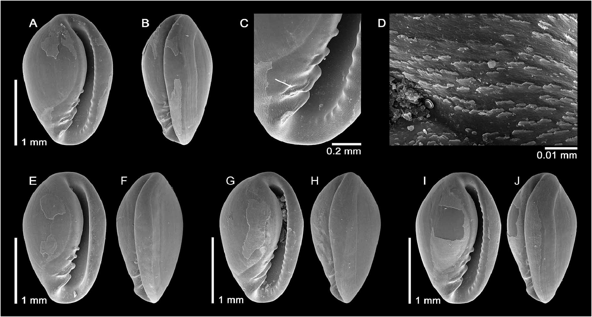
Granulina crassa Smriglio, Gubbioli & Mariottini, 2000: 55 View in CoL , figs 2, 9–12; type locality: off Mauritania, 80– 100 m.
Smriglio et al. (2000) reported 14 type specimens, of which some empty shells from off Mauritania ( 80– 100 m) and off Western Sahara ( 50 m) without further details. The holotype was deposited in Bologna Zoology Museum (MZB14030). Thirteen paratypes were retained in private collections.
Material examined (509 shells)
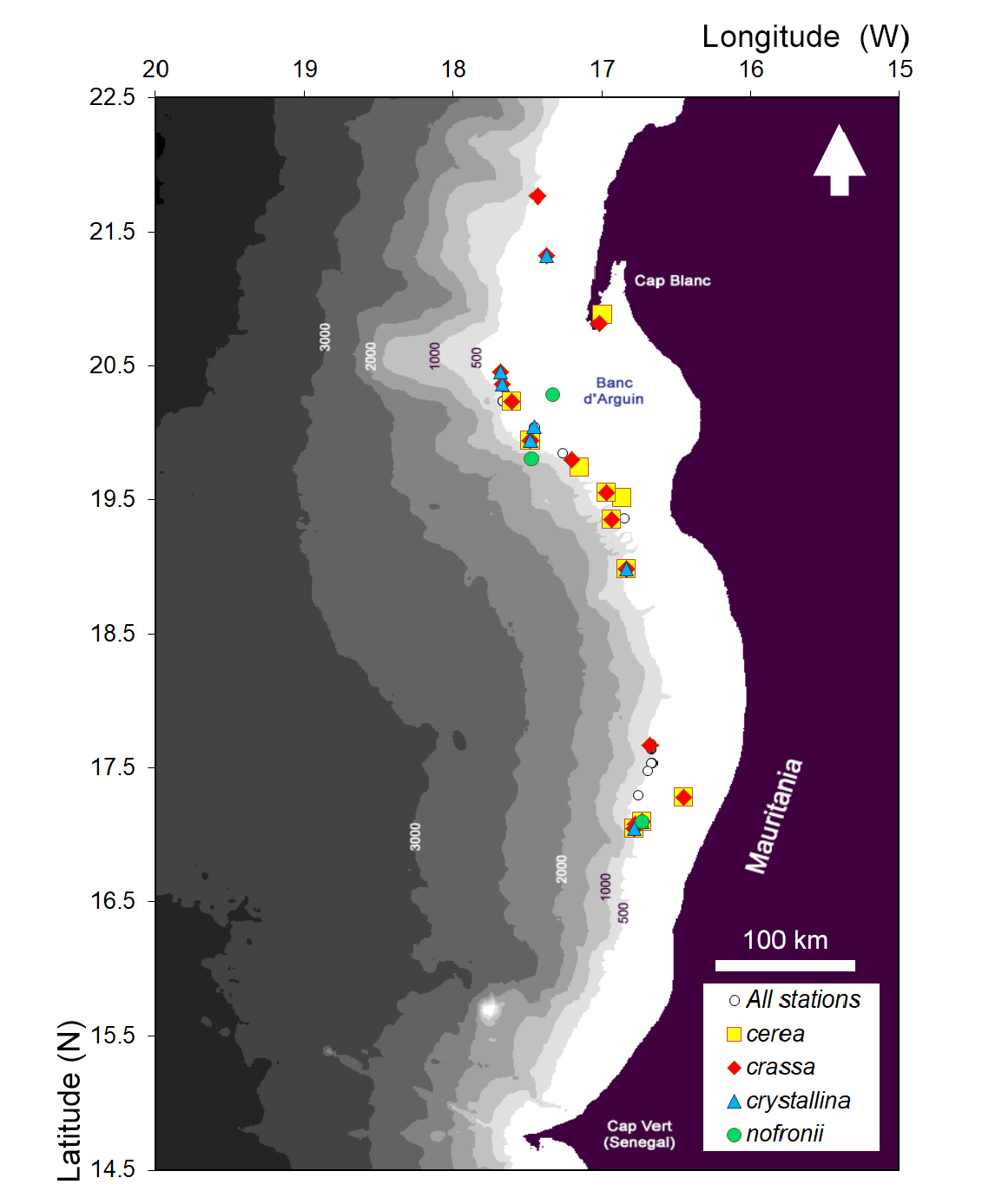
MAURITANIA – Banc d’Arguin • 5 shells; 20.3667° N, 17.6667° W; depth 200 m; 28 Oct. 1978; CANCAP stn 3.120; sandy clay with shells; van Veen grab; RMNH.MOL.351803 GoogleMaps • 12 shells; 18.9833° N, 16.8333° W; depth 203 m; 30 Oct. 1978; CANCAP stn 3.140; sandy clay with shells; van Veen grab; RMNH.MOL.351804 GoogleMaps • 3 shells; 18.9833° N, 16.8333° W; depth 203 m; 30 Oct. 1978; CANCAP stn 3.140; sandy clay with shells by van Veen grab; RMNH.MOL.351805 GoogleMaps • 28 shells; 19.35° N, 16.9333° W; depth 200 m; 31 Oct. 1978; CANCAP stn 3.154; sandy clay with shells; van Veen grab; RMNH.MOL.351806 GoogleMaps • 60 shells; 19.94° N, 17.48° W; depth 151 m; 22 May 1988; Tyro Mauritania I stn B5; SaM GoogleMaps • 2 shells; Arguin mud wedge; 20.2353° N, 17.6029° W; depth 111 m; 24 Oct. 2010; MSM16–3 stn GeoB14703; box core in muddy silt; SaM GoogleMaps • 40 shells; Arguin mud wedge; 20.4569° N, 17.6795° W; depth 142 m; 24 Oct. 2010; MSM16–3 stn GeoB14706; box core in muddy silt; SaM GoogleMaps • 1 shell; Baie du Levrier ; 20.8169° N, 17.0186° W; depth 13 m; 31 Oct. 2010; MSM16– 3 stn GeoB14780; bottom grab in muddy silt; SaM GoogleMaps • 1 shell; southern Banc d'Arguin; 19.7967° N, 17.2034° W; depth 105 m; 6 Nov. 2010; MSM16–3 stn GeoB14850; box core in muddy silt; SaM. GoogleMaps – Timiris mud wedge • 2 shells; 19.5506° N, 16.9731° W; depth 100 m; 8 Nov. 2010; MSM16– 3 stn GeoB14866; box core in silty sand; SaM. GoogleMaps – Banda Mound Complex • 1 shell; 17.6699° N, 16.6736° W; depth 505 m; 14 Nov. 2010; MSM16–3 stn GeoB14898; bottom grab in muddy silt; SaM. GoogleMaps – off Nouakchott • 3 shells; 17.045° N, 16.7783° W; depth 202 m; 11 Feb. 1977; M44 stn 133–KG613; box core; SMF GoogleMaps • 5 shells; 17.045° N, 16.7783° W; depth 208 m; 11 Feb. 1977; M44 stn 133–KG615; box core; SMF GoogleMaps • 1 shell; 17.0817° N, 16.775° W; depth 312 m; 12 Feb. 1977; M44 stn 135–KG625; box core; SMF GoogleMaps • 25 shells; 17.0967° N, 16.73° W; depth 127 m; 17 Feb. 1977; M44 stn 193–KG626; box core; SMF GoogleMaps • 5 shells; 17.0967° N, 16.73° W; depth 126 m; 17 Feb. 1977; M44 stn 193–KG627; box core; SMF GoogleMaps • 72 shells; off Nouakchott ; 17.2783° N, 16.4483° W; depth 87 m; 13 Feb. 1982; M60 stn 77–KG960; box core; SMF GoogleMaps • 85 shells; 17.2783° N, 16.4483° W; depth 88 m; 13 Feb. 1982; M60 stn 77–KG961; box core; SMF GoogleMaps • 55 shells; 17.2783° N, 16.4483° W; depth 87 m; 13 Feb. 1982; M60 stn 77–KG965; box core; SMF GoogleMaps .
WESTERN SAHARA – off Cap Blanc • 62 shells; 21.325° N, 17.37° W; depth 81 m; 25 Feb. 1977; M44 stn 235–KG649; box core; SMF GoogleMaps • 1 shell; 21.7683° N, 17.4333° W; depth 125 m; 20 Feb. 1982; M60 stn 88–KAD268; SMF. GoogleMaps – North of Dakhla • 39 shells; 25.0000° N, 15.5167° W; depth 53 m; 21 Feb. 1975; M36 stn 94–KG2; box core; SMF GoogleMaps • 1 shell; 25.18333° N; 15.80333° W; depth 87 m; 22 Feb. 1975; M36 stn 95–KG6; box core; SMF GoogleMaps .
Remarks
Smriglio et al. (2000) indicated a holotype height of 1.9 mm; our set indicates a maximum height of 2.1 mm. The species is the smallest member of the four coffin-shaped species from Mauritania. It has very weak labial denticles that occasionally may be absent, even though these specimens may be subadult. Granulina crassa lacks an (ab-)apical rostration.
The species is known from empty shells in the latitudinal range 17.0– 25.2° N. The full bathymetric range is 13–505 m; it is commonly found on the lower shelf at depths of 80–210 m in silty sand.
No known copyright restrictions apply. See Agosti, D., Egloff, W., 2009. Taxonomic information exchange and copyright: the Plazi approach. BMC Research Notes 2009, 2:53 for further explanation.
|
Kingdom |
|
|
Phylum |
|
|
Class |
|
|
SubClass |
Caenogastropoda |
|
Order |
|
|
SuperFamily |
Volutoidae |
|
Family |
|
|
Genus |
Granulina crassa Smriglio, Gubbioli & Mariottini, 2000
| Elm, Laura-Marie Von & Hoffman, Leon 2024 |
Granulina crassa
| Smriglio C. & Gubbioli F. & Mariottini P. 2000: 55 |