
Habronestes hunti, Baehr, 2003
|
publication ID |
https://doi.org/10.3853/j.0067-1975.55.2003.1389 |
|
persistent identifier |
https://treatment.plazi.org/id/03FA87BC-5957-FF8D-FC08-FAAEFE88FB7E |
|
treatment provided by |
Felipe |
|
scientific name |
Habronestes hunti |
| status |
sp. nov. |
Habronestes hunti View in CoL n.sp.
Figs. 65 View Figs , 72, 73 View Figs , 110 View Figs , 115, 116 View Figs , 141 View Figs
Type material. HOLOTYPE 3: NSW, East Kunderang Trail , 1.35 km E of West Kunderang Trail, 30°48'41"S 152°2'55"E, 4.ii–9.iv. 1993, 890 m, G/C, AM KS83932 GoogleMaps . PARATYPES: same data as holotype: 1♀, 1133, AM KS39157 ; 13 as previous, QM S60825 View Materials ; 1533 Richmond Range SF, Mt Brown Rd , 0.1 km N from Y intersection GoogleMaps , 28°37'56"S 152°43'18"E, 4.ii–9.iv. 1993, 480 m, G/C, AM KS36026 ; 1 ♀, 2533 0.5 km from Wheatley Ck Rd on Camp Ck Rd , leasehold land GoogleMaps , 28°47'0"S 152°19'29"E, 4.ii–9.iv. 1993, 550 m, G/C, AM KS36268 ; 1 ♀, 933 2.8 km from Wheatley Ck access Rd (on Camp Ck), leasehold land GoogleMaps , 28°47'10"S 152°18'37"E, 4.ii–9.iv. 1993, 435 m, G/C, AM KS36250 ; 5 33 240 m E of jnctn of Kunderang East & Kunderang West Rds GoogleMaps , 30°48'53"S 152°2'9"E, 4.ii–9.iv. 1993, 900 m, G/C, AM KS39160 ; 3 33 3.45 km along Wheatley Ck Access Rd on Camp Ck Rd GoogleMaps , 28°47'16"S 152°18'56"E, 4.ii–9.iv. 1993, 470 m, G/C, AM KS36262 ; 13 Ballengarra SF, Cooperabung Range Rd, 1.1 km S of Narang Rd GoogleMaps , 31°12'54"S 152°42'44"E, 4.ii–9.iv. 1993, 200 m, G/C, AM KS39182 ; 733 Ballengarra SF, Cooperabung Range Rd, 4.5 km N of Narang Rd GoogleMaps , 31°11'46"S 152°42'25"E, 4.ii–9.iv.1993, 90 m, G/C, AM KS39181 ; 13 Beaury SF Rocky Waterholes Rd GoogleMaps , 28°33'12"S 152°19'45"E, 4.ii–9.iv. 1993, 630 m, G/C, AM KS36096 ; 11 33 Boonoo SF, jnctn Woolool Wooloolni and Basket Swamp Rd GoogleMaps , 28°55'49"S 152°8'21"E, 4.ii–9.iv.1993, 1070 m, G/C, AM KS36340 ; 1 3 Boonoo SF, Timbarra Trig GoogleMaps , 28°56'41"S 152°8'31"E, 4.ii–9.iv.1993, 1130 m, G/C, AM KS36346 ; 13 Boorook SF, 1 km NW Boorook Ck GoogleMaps jnctn, on Conlongan Rd, Midway between Boorook Ck and Gilgurry Ck on Conlongan Rd ,
28°51'24"S 152°11'27"E, 4.ii–9.iv. 1993, 980 m, G/C, AM KS36323 ; 1 ♀, 433 Boorook SF, 300 m NW of Gilgurry Mt GoogleMaps , 28°47'23"S 152°10'56"E, 4.ii–9.iv. 1993, 980 m, G/C, AM KS36315 ; 14 33 Boundary Ck SF, 1.9 km along Sheas Nob Rd from Boundary Ck Rd GoogleMaps , 29°59'25"S 152°34'33"E, 4.ii–9.iv. 1993, 550 m, G/C, AM KS39022 ; 2 ♀♀, 1633 Boundary Ck SF, 100 m S of jnctn of Dilli & Boundary Ck Rds GoogleMaps , 29°58'14"S 152°36'51"E, 4.ii–9.iv. 1993, 540 m, G/C, AM KS39012 ; 3 33 Bulga SF, 1.2 km up 4WD track N of Grey Gums Forest Rd GoogleMaps 2.1 km from Douglas River Rd , 31°32'56"S 152°14'51"E, 4.ii–9.iv. 1993, 620 m, G/C, AM KS39186 ; 1♀, 333 Bulga SF, Grey Gums Forest Rd 1.1 km from Doyles River Rd GoogleMaps , 31°33'35"S 152°14'36"E, 4.ii–9.iv. 1993, 620 m, G/C, AM KS39187 ; 3♀♀, 13 Bulga SF, Padmans Rd nr intersection of Pole Dump Rd GoogleMaps , 31°36'58"S 152°10'39"E, 4.ii–9.iv. 1993, 730 m, G/C, AM KS39190 ; 1♀ Bulls Ground SF nr Wauchope GoogleMaps , 31°33'S 152°38'E, 10.ii.1991, dry euc. open forest, Plot 3B4–burnt, 6–13 Feb 1991, A. York, NSW Forestry, AM KS43349 ; 13 Bundjalung NP, hilltop on ridge between Big Marsh & Esk River GoogleMaps , 29°17'35"S 153°16'40"E, 4.ii–9.iv.1993, 23 m, G/C, AM KS39016 ; 433 Bundjalung NP, nr new gravel quarry GoogleMaps , 29°17'12"S 153°16'40"E, 4.ii–9.iv.1993, 20 m, G/C, AM KS39017 ; 1 ♀, 1233 Chaelundi SF, 1.2 km W along Stockyard FT from Chandlers Ck GoogleMaps , 29°56'48"S 152°31'46"E, 4.ii–9.iv. 1993, 450 m, G/C, AM KS39015 ; 9 33 Chaelundi SF, 3.8 km W along Stockyard FTfrom Chandler Ck GoogleMaps , 29°57'50"S 152°31'23"E, 4.ii–9.iv. 1993, 450 m, G/C, AM KS39025 ; 1 ♀, 13 Conglomerate SF, along new logging rd below dam, 0.55 km SW along Old Growth Rd , N side of rd GoogleMaps , 30°6'55"S 153°4'55"E, 4.ii–9.iv. 1993, 380 m, G/C, AM KS39020 ; 13, as previous, AM KS48712 ; 3♀♀, 2033 Conglomerate SF, 1.7 km NW on Murphys Rd from Madmans Ck Bridge , on S side of ridge GoogleMaps , 30°3'57"S 153°5'58"E, 4.ii–9.iv. 1993, 220 m, G/C, AM KS39013 ; 833 Conglomerate SF, 100 m SW of jnctn of Hallgraths Trail & Sherwood rd GoogleMaps , 30°7'0"S 153°3'14"E, 4.ii–9.iv. 1993, 320 m, G/C, AM KS39019 ; 2♀♀, 2433 Conglomerate SF, 700 m N along Murphys Rd, from Tea Tree Rd , W side of rd, S of Madmans Ck GoogleMaps , 30°4'52"S 153°6'24"E, 4.ii–9.iv. 1993, 130 m, G/C, AM KS39023 ; 1 ♀ Dorrigo NP, off Dorrigo-Bellingen Rd, about 20 km from Bellingen (to E of rd) about 500 m S of Newell Falls GoogleMaps , 30°23'55"S 152°44'56"E, 4.ii–9.iv. 1993, 410 m, G/C, AM KS35631 ; 1133 East Kunderang Trail , 2.1 km E of West Kunderang Trail GoogleMaps , 30°49'0"S 152°3'25"E, 4.ii–9.iv. 1993, 845 m, G/C, AM KS39161 ; 13 Enfield SF, Dodds Fire Trail, 1 km from Enfield Rd GoogleMaps , 31°23'44"S 151°53'6"E, 4.ii–9.iv.1993, 1050 m, G/C, AM KS39159 ; 1933 Enfield SF, Mummel Forest Rd, 7.6 km N of jnctn with Enfield Forest Rd GoogleMaps , 31°17'0"S 151°51'17"E, 4.ii–9.iv.1993, 1340 m, G/C, AM KS39158 ; 13 Euroka, Blue Mountains GoogleMaps , 33°45'S 150°13'E, 8.iii.1965, A.E. Speechley, AM KS15596 ; 1733 Gilgurry SF, Rivertree Fire Trail , on ridge 2 km NNE from t/o GoogleMaps , 28°45'18"S 152°15'52"E, 4.ii–9.iv. 1993, 770 m, G/C, AM KS36245 ; 2♀♀, 5633 Headwaters of Wheatley Ck, leasehold Land GoogleMaps , 28°45'7"S 152°19'44"E, 4.ii–9.iv. 1993, 550 m, G/C, AM KS36265 ; 13 Kangaroo River SF, 200 m E of a point 550 m along Burns Rd GoogleMaps , 30°4'36"S 152°52'5"E, 4.ii–9.iv. 1993, 320 m, G/C, AM KS39021 ; 13 Kangaroo River SF, 700 m E of Arinya Rd GoogleMaps on a logging track 900 m from Burns Rd jnctn, 30°4'36"S 152°52'5"E, 4.ii–9.iv. 1993, 360 m, G/C, AM KS39014 ; 333 Karuah SF, 0.1 km W along Hobart Forest Rd from Foleys Rd GoogleMaps , 32°35'12"S 151°55'14"E, 4.ii–9.iv.1993, 10 m, G/C, AM KS39180 ; 1533 Karuah SF, NE slope of Little Mountain , just W of Karuah Rd GoogleMaps , 32°36'17"S 151°56'41"E, 4.ii–9.iv.1993, 40 m, G/C, AM KS39189 ; 233 Karuah SF, SE of jnctn Little Mtn & Hobart Forest Rds GoogleMaps , 32°35'45"S 151°56'15"E, 4.ii–9.iv.1993, 10 m, G/C, AM KS39188 ; 1 3 Kirrawee GoogleMaps , 34°2'S 151°4'E, 26.iii.1967, AM KS15677 ; 1♀, 1733 London Bridge SF, 3.7 km SW of London Bridge Lookout GoogleMaps , end of FC survey rd, off London Bridge Rd overlooking gorge , 29°51'31"S 152°12'47"E, 4.ii– 9.iv. 1993, 960 m, G/C, AM KS36393 ; 233 McPherson Range GoogleMaps , 28°22'S 152°50'E, 23.ii.1989, hoop pine, Mt Warning Caldera Survey, UNE, 300 m, Smith, Hines, Pugh & Webber, AM KS55703 ; 3♀♀, 303 Morgan Ck , 5.9 km NE from creek crossing GoogleMaps , 28°46'31"S 152°18'45"E, 4.ii– 9.iv. 1993, 620 m, G/C, AM KS36256 ; 733 Morgans Ck, 4.5 km NE from creek crossing on Wheatley Ck Rd on Wheatley Ck access road, leasehold land GoogleMaps , 28°46'37"S 152°18'19"E, 4.ii–9.iv. 1993, 590 m, G/C, AM KS36259 ; 213 Nerang SF, 0.45 km E along Boundary Rd from Masonite Track GoogleMaps , 32°32'16"S 152°7'40"E, 4.ii–9.iv. 1993, 130 m, G/C, AM KS39185 ; 933 Nerang SF, 0.3 km S along Coxs Fence Trail from Boundary Rd GoogleMaps , 31°38'19"S 152°9'30"E, 4.ii–9.iv.1993, 70 m, G/C, AM KS39184 ; 1 3 Oakwood SF, 0.3 km along Sydney Plain Hut Track from London Bridge Fire Trail GoogleMaps , 29°55'25"S 152°5'58"E, 4.ii–9.iv. 1993, 970 m, G/C, AM KS36383 ; 13 Oakwood SF, 0.65 km N along Oakwood FT from London Bridge Fire Trail GoogleMaps , 29°53'45"S 152°5'41"E, 4.ii–9.iv.1993, 1060 m, G/C, AM KS36376 ; 233 Oakwood SF, 250 m upstream of London Bridge Fire Trail, House Ck GoogleMaps , 29°54'23"S 152°5'25"E, 4.ii–9.iv.1993, 1000 m, G/ C, AM KS36374 ; 13 Port Hacking GoogleMaps , 34°4'S 151°7'E, 1.iii.1969, Mascord coll. no.490, N. Allen, AM KS15597 ; 213 Ramornie SF, Main Ck, track off Mt Tindal Rd GoogleMaps , 29°43'1"S 152°38'24"E, 4.ii–9.iv. 1993, 110 m, G/C, AM KS39480 ; 1♀, 313 Ramornie SF, Mt Tindal Rd GoogleMaps , 29°42'12"S 152°35'26"E, 4.ii–9.iv. 1993, 380 m, G/C, AM KS39483 ; 1 ♀, 1133 Ramornie SF, Mt Tindal Rd GoogleMaps , 29°41'49"S 152°35'0"E, 4.ii–9.iv. 1993, 490 m, G/C, AM KS39484 ; 1♀, 2533 Ramornie SF, track off Mt Tindal Rd GoogleMaps , 29°42'41"S 152°37'36"E, 4.ii–9.iv. 1993, 220 m, G/C, AM KS39481 ; 1033 Ramornie SF, track off Mt Tindal Rd, headwaters of Valorem Ck GoogleMaps , 29°42'18"S 152°35'52"E, 4.ii–9.iv. 1993, 380 m, G/C, AM KS39482 ; 30 3 Ramornie SF, track off T-Ridge Rd GoogleMaps , 29°43'0"S 152°33'23"E, 4.ii– 9.iv. 1993, 150 m, G/C, AM KS39479 ; 1♀, 533 Ramornie SF, T-Ridge Rd GoogleMaps , 29°43'23"S 152°34'11"E, 4.ii–9.iv. 1993, 420 m, G/C, AM KS39477 ; 1♀, 213 Ramornie SF, T-Ridge Rd GoogleMaps , 29°43'13"S 152°33'38"E, 4.ii– 9.iv. 1993, 300 m, G/C, AM KS39478 ; 313 Richmond Range SF, jnctn of Wattle Ck Rd and Wattle Ck GoogleMaps , 28°38'9"S 152°46'40"E, 4.ii–9.iv. 1993, 130 m, G/C, AM KS36045 ; 203 Richmond Range SF, Oaky Ck Rd GoogleMaps , 28°38'39"S 152°45'45"E, 4.ii–9.iv. 1993, 230 m, G/C, AM KS36050 ; 1 3, as previous, AM KS36052 ; 2733 Richmond Range SF, Wattle Ck Rd GoogleMaps , 28°38'42"S 152°46'29"E, 4.ii–9.iv. 1993, 220 m, G/C, AM KS36060 ; 5 33 Ridge between Camp Ck and Stydgy Ck GoogleMaps , leasehold Land, 28°46'18"S 152°18'8"E, 4.ii–9.iv. 1993, 640 m, G/C, AM KS36242 ; 1 3 St Georges Basin GoogleMaps , 35°5'S 150°35'E, i.1984, I. Buddle, AM KS22639 ; 13 Styx River SF off Cunnawarra Trail, about 2 km N Cunnawarra Ck GoogleMaps , 30°32'49"S 152°20'16"E, 4.ii–9.iv.1993, 1070 m, G/C, AM KS35627 ; 1 3 Tweed Range GoogleMaps , 28°25'S 153°1'E, 16.ii.1989, wet sclerophyll, Mt Warning Caldera Survey, UNE, 400 m, Smith, Hines, Pugh & Webber, AM KS55699 ; 2♀♀, 2533 Wallaroo SF, Flaggy Ck, 0.95 km S along Ripleys Trail from Clarence Town Rd GoogleMaps , 32°36'3"S 151°48'7"E, 4.ii–9.iv.1993, 20 m, G/C, AM KS39183 ; 1033 Wallaroo SF, Gilmore Lookout GoogleMaps , 32°37'27"S 151°47'16"E, 4.ii–9.iv. 1993, 210 m, G/C, AM KS39191 ; 2 33 Washpool NP, North West Fire Trail GoogleMaps , 29°27'36"S 152°17'25"E, 4.ii–9.iv. 1993, 950 m, G/C, AM KS36405 ; 333 Washpool NP, North West Fire Trail GoogleMaps , 29°27'30"S 152°16'52"E, 4.ii–9.iv. 1993, 950 m, G/C, AM KS36418 ; 1 3, as previous, AM KS56168 ; 233 Washpool NP, Washpool Forest Way GoogleMaps , 29°24'47"S 152°17'0"E, 4.ii–9.iv. 1993, 860 m, G/C, AM KS36295 ; 1 3 Bendoura SF, 700 m E of Wallaces Gap GoogleMaps , 35°34'37"S 149°41'16"E, 16.iii.1999, J. Tarnawski & S. Lassau, AM KS55853 ; 13 Dampier SF, Ross Rixon Rd GoogleMaps , 36°2'56"S 149°57'21"E, 11.iii.1999, L. Wilkie, R. Harris & H. Smith, AM KS55854 ; 13 Dampier SF, Ross Rixon Rd GoogleMaps , 36°2'56"S 149°57'36"E, 11.iii.1999, L. Wilkie, R. Harris & H. Smith, AM KS55857 ; 13 Nerrigundah Mt Rd , Dampier SF GoogleMaps , 36°7'58"S 149°56'2"E, 10.iii.1999, J. Tarnawski & S. Lassau, AM KS55855 ; 1♀ Rocky Waterholes Rd , Beaury SF GoogleMaps , 28°32'S 152°20'E, 9.iv.1993, 4.ii–9.iv. 1993, 705 m, G/C, AM KS56166 ; 13 Tobacco Pinch Rd , Bodalla SF GoogleMaps , 36°10'55"S 150°2'56"E, 10.iii.1999, J. Tarnawski & S. Lassau, AM KS55856 ; 13 Tuross River Rd, Bodalla SF GoogleMaps , 36°11'13"S 149°56'13"E, 10.iii.1999, L. Wilkie, R. Harris & H.Smith, AM KS55858 ; 13 7.5 km S of Nelligen, Mogo GoogleMaps SF, 35°43'19"S 150°6'50"E, 8.iii.1999, J. Tarnawski & S. Lassau, AM KS55861 ; 13 Brou Lake Rd, Narooma, Site 3 GoogleMaps , 36°7'15"S 150°2'49"E, 9.iii.1999, L. Wilkie, R. Harris & H. Smith, AM KS55852 ; 13 Highway 54, 32 km NW of Batemans Bay GoogleMaps , 35°33'7"S 149°59'38"E, 16.iii.1999, J. Tarnawski & S. Lassau, AM KS55870 ; 13 jnctn of Skid Ridge & North Head Rds , Murramarang NP GoogleMaps , 35°41'9"S 150°16'4"E, 17.iii.1999, L. Wilkie, R. Harris & H. Smith, AM KS55862 ; 13 Orange Ridge Rd , Bodalla SF GoogleMaps , 36°16'55"S 149°53'31"E, 12.iii.1999, L. Wilkie, R. Harris & H. Smith, AM KS55863 ; 13 Tuross River Rd, Bodalla SF GoogleMaps , 36°10'51"S 149°56'41"E, 10.iii.1999, L. Wilkie, R. Harris & H. Smith, AM KS55859 ; 13 Tuross River Rd, Bodalla SF GoogleMaps , 36°11'16"S 149°56'16"E, 10.iii.1999, L. Wilkie, R. Harris & H. Smith, AM KS55871 ; 13 Turtle Creek Fire Trail, Monga SF GoogleMaps , 35°38'20"S 149°55'55"E, 15.iii.1999, L. Wilkie, R. Harris & H. Smith, AM KS55860 GoogleMaps .
Diagnosis. Eyes equal sized. Abdomen with 3 pairs of large white patches on anterior part and 3 patches in front of spinnerets. Tibiae and metatarsi I, II with irregular band of short spines ventrally in males. Extremely small DTiA, LTA with transverse plate.
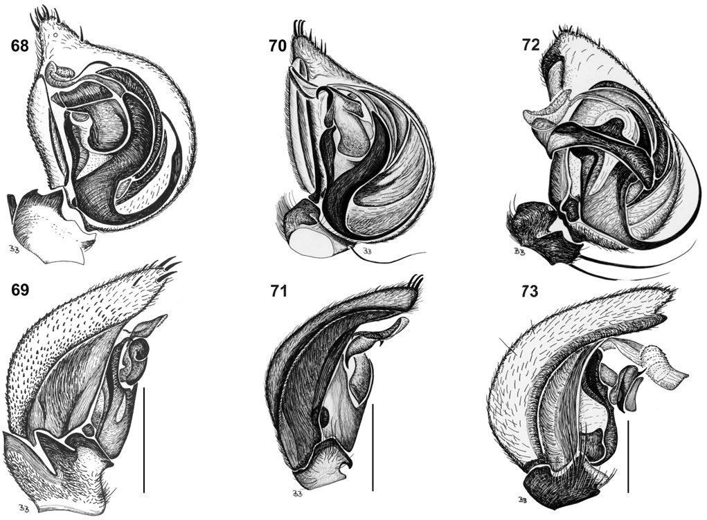
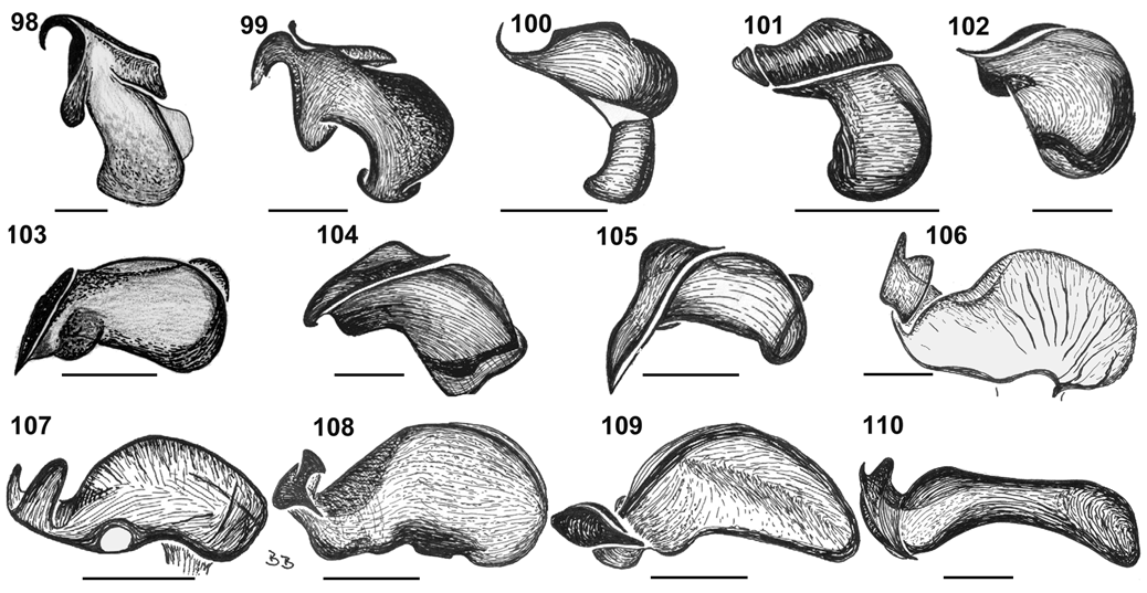
Description. Male ( holotype). Total length 7.56; carapace 3.72 long, 2.84 wide; 0.88 high; cl/cw 1.31; sternum 1.80 long, 1.56 wide; sl/sw 1.15. Abdomen 3.84 long, 2.48 wide. Colour. Carapace, sternum, chelicerae sepia brown; maxillae, labium sepia brown, distally white. Abdomen sepia brown with 3 pairs of white patches on anterior part and 3 patches in front of spinnerets; laterally with 2 long white patches equal in length; ventrally with 1 longitudinal white stripe from epigastric fold to near tracheal spiracle and 1 pair of white patches near tracheal spiracle. Legs yellow; clearly annulated; legs I–IV with white coxa, sepia brown trochanter, proximal 1 3 –½ of femora white and distal part sepia brown. Eyes. In 2 rows each with 4 eyes, both rows procurved. Nearly equal sized. Eye group width 0.51 of headwidth; AME 0.18; ALE 0.16; PME 0.18; PLE 0.18; AME–AME 0.04; AME–ALE 0.04; ALE–PLE 0.04; PME– PME 0.12; PME–PLE 0.16. MOQ: AME–PME 0.52; AME– AME 0.40; PME–PME 0.48. Clypeus & chilum. Clypeus 0.88 high; chilum divided. Legs. Length formula 4123; tibiae and metatarsi I, II with a band of short spines ventrally. Male palp ( Figs. 72, 73 View Figs , 110 View Figs ). RCF deep, almost running the entire cymbium length. LTA with a long vertical stalk, and T-shaped plate; DTA with a thin stalk; VTA with sharp tip. Tibiae short; DTiA short; VTiA ( Fig. 73 View Figs ).
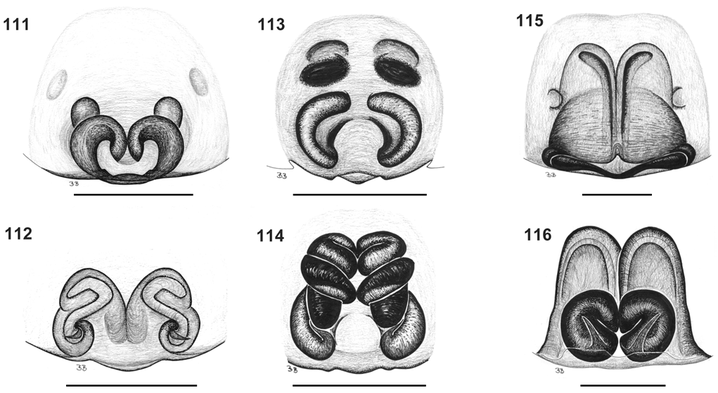
Female ( paratype AM KS39013). Total length 10.1; carapace 4.29 long, 2.94 wide; 1.55 high; cl/cw 1.46; sternum 1.88 long, 1.76 wide; sl/sw 1.07. Abdomen 5.83 long, 3.50 wide. Colour. Same as male. Eyes. Eye group width 0.5 of headwidth; AME 0.19; ALE 0.20; PME 0.22; PLE 0.22; AME–AME 0.04; AME–ALE 0.06; ALE–PLE 0.08; PME–PME 0.16; PME–PLE 0.20. MOQ: AME–PME 0.58; AME–AME 0.42; PME–PME 0.60. Clypeus 1.02 high. Legs. Same as male, but without irregular band of short ventral spines on tibiae and metatarsi I, II. Epigyne ( Figs. 115, 116 View Figs ). With small paired halfmoon-shaped copulatory openings laterally. Vulva with very large atriumlike copulatory ducts ending in almost touching spermathecae.
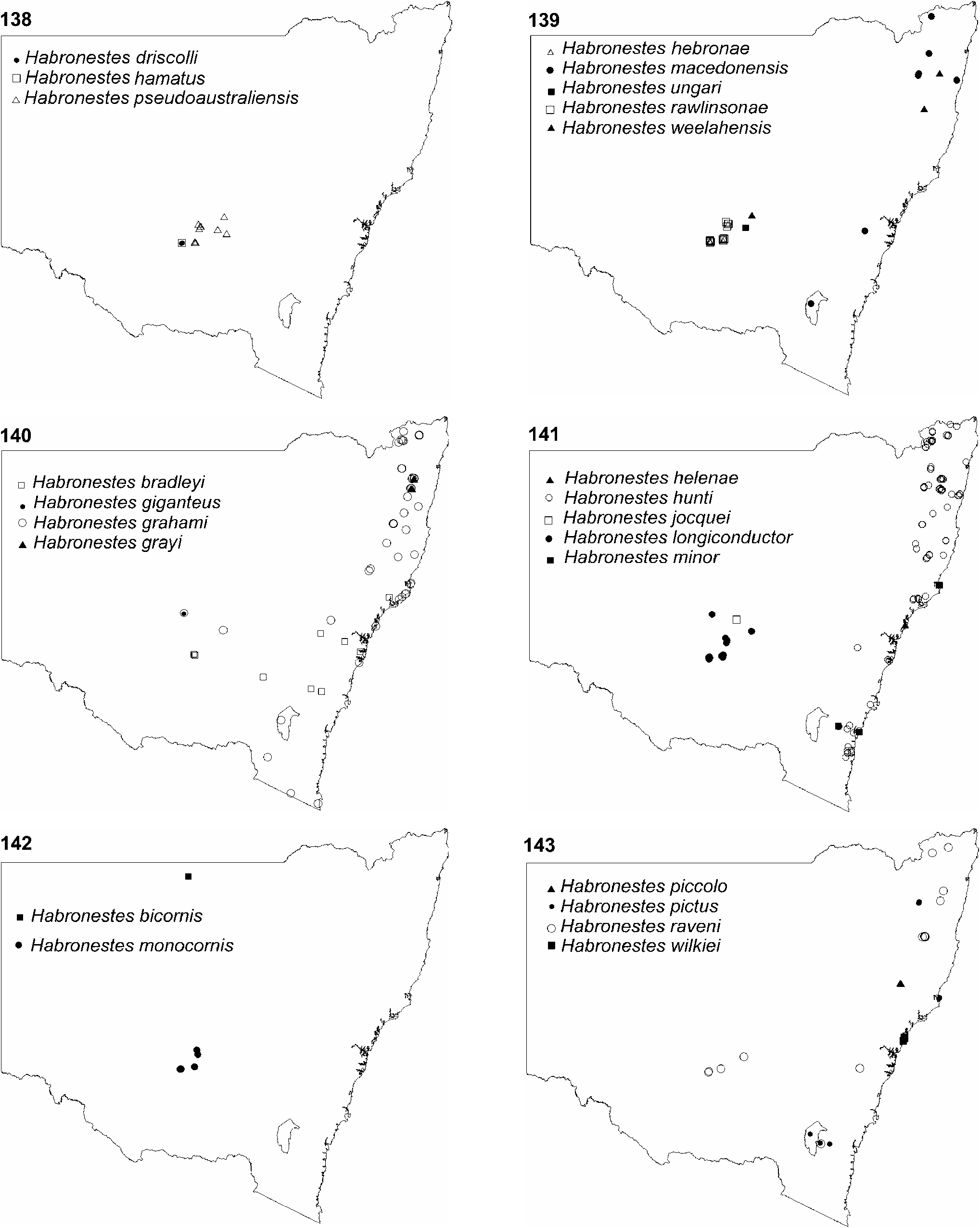
Distribution. Widespread in eastern New South Wales ( Fig. 141 View Figs ).
Etymology. Species name is a patronym in honour of Dr Glenn Hunt of the Australian Museum, an experienced arachnologist, whose recent death was a great loss to Australian arachnology.

| AM |
Australian Museum |
| QM |
Queensland Museum |
| R |
Departamento de Geologia, Universidad de Chile |
No known copyright restrictions apply. See Agosti, D., Egloff, W., 2009. Taxonomic information exchange and copyright: the Plazi approach. BMC Research Notes 2009, 2:53 for further explanation.
|
Kingdom |
|
|
Phylum |
|
|
Class |
|
|
Order |
|
|
Family |
|
|
Genus |