
Agonocryptus varus ( Brullé, 1846 )
|
publication ID |
https://doi.org/10.11646/zootaxa.5178.6.3 |
|
publication LSID |
lsid:zoobank.org:pub:19F4AA27-40EA-4434-B7A9-BB99EBE39CE0 |
|
DOI |
https://doi.org/10.5281/zenodo.7044133 |
|
persistent identifier |
https://treatment.plazi.org/id/41598272-FF9D-FF86-AF6F-FF02FAF0FDD6 |
|
treatment provided by |
Plazi |
|
scientific name |
Agonocryptus varus ( Brullé, 1846 ) |
| status |
|
Agonocryptus varus ( Brullé, 1846) View in CoL
( Figs 15A–P View FIGURE 15 , 20H View FIGURE 20 , 21I View FIGURE 21 )
Mesostenus varus Brullé, 1846 . Original description.
Agonocryptus varus: Townes, 1966 . Catalog.
Agonocryptus varus: Gupta, 1982 . Subspecies assignment, description, male and female, keyed, map.
Agonocryptus varus: Yu et al., 2016 . Catalog.
Variation. Clypeal groove black ( Figs 15F–J View FIGURE 15 ) ( vs. concolorous with clypeus); pronotal collar stripe often (27%) entirely yellow or narrowed, but not interrupted ( Figs 15A–C View FIGURE 15 ) ( vs. yellow stripe interrupted centrally); hind coxa dorsally often (33%) with a narrow yellow streak ( Figs 15A, D, K View FIGURE 15 ) ( vs. absent); hind coxa dorso-basally with a small black spot ( Fig. 15K View FIGURE 15 ) ( vs. absent); fore wing sometimes (16%) hyaline with fuscous stripes both medially and apically ( Fig. 15C View FIGURE 15 ) ( vs. without stripes); T2 basally with yellow band ( vs. absent), pre-apically with two dark brown spots ( Figs 15L–O View FIGURE 15 ) ( vs. absent), apex centrally with transversal yellow mark ( Figs 15M–O View FIGURE 15 ) ( vs. absent).
Three specimens (E. E. Jataí and Barretos, both in São Paulo State, southeastern Brazil) have hind coxa dorso basally with a brown mark ( Fig. 15B View FIGURE 15 ) ( vs. absent).
One specimen from Simla ( Trinidad & Tobago) has T2–6 apical margin centrally with whitish marks ( Fig. 15P View FIGURE 15 ) ( vs. absent).
Comments. A pronotal collar with an interrupted yellow stripe is cited by Gupta (1982) as diagnostic for the subspecies, but a complete stripe was observed for about 1/3 of the specimens studied for the present work, namely those from Altamira (Pará State, northern Brazil), Estação Ecológica Jataí (Luis Antônio), Sales, Pindorama, and Barretos ( São Paulo State, southeastern Brazil), and Department Santa Cruz ( Bolivia).
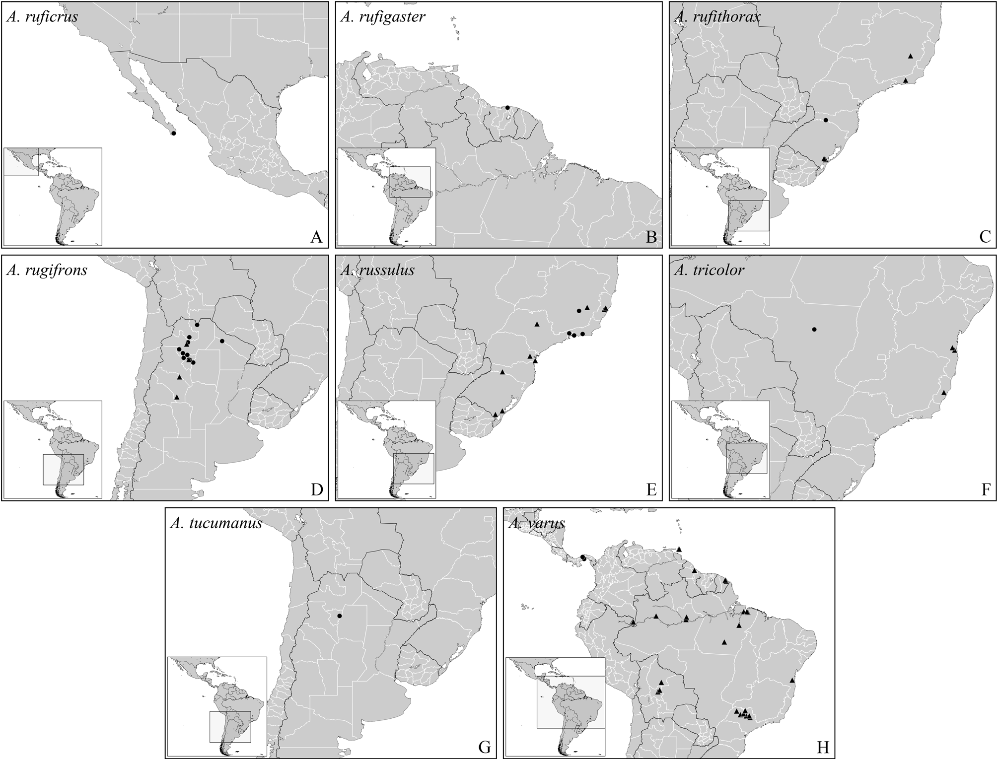
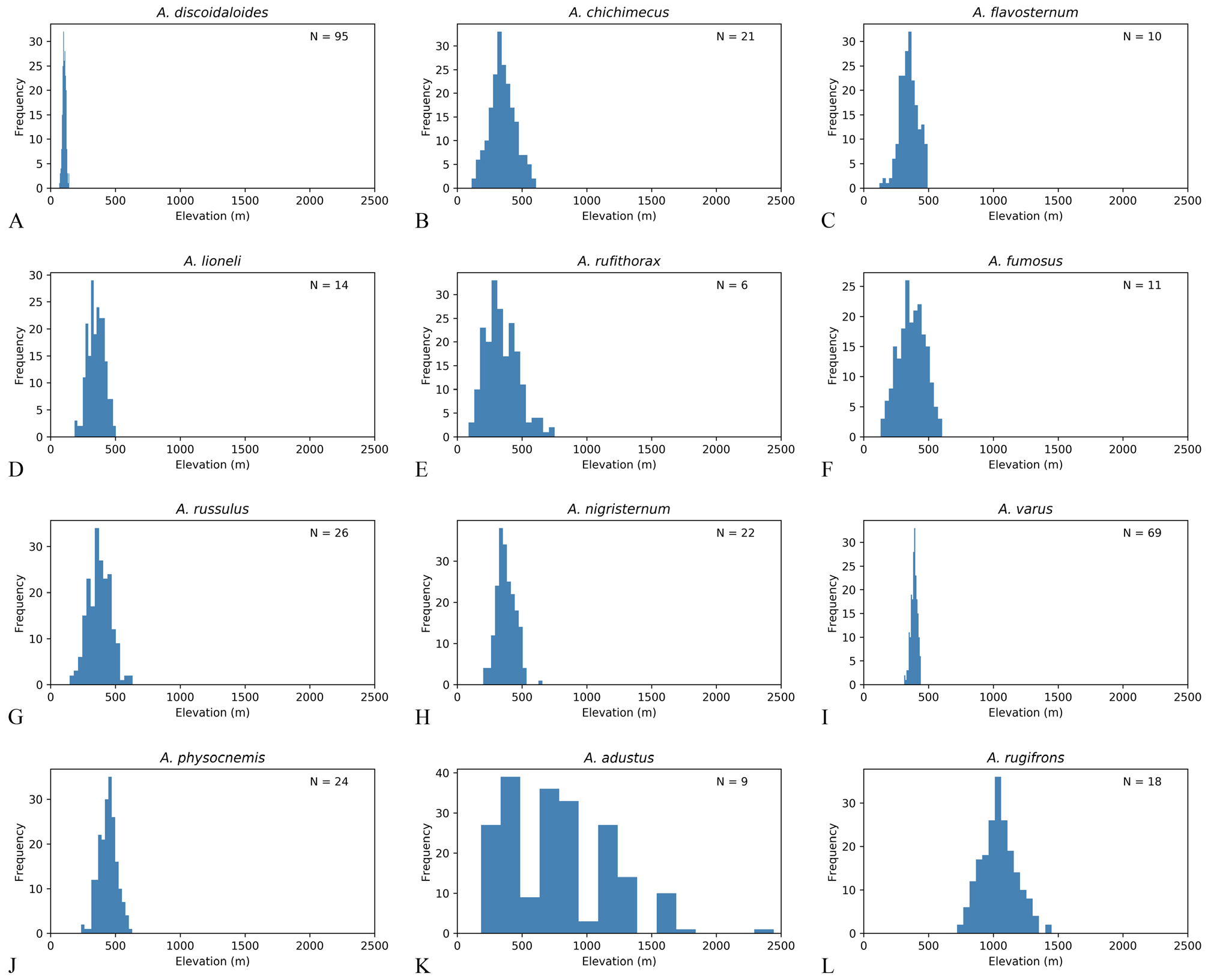
Distribution. Bolivia NR, Brazil NR (Amazonas, Bahia, Pará, São Paulo), Colombia NR, French Guyana NR, Panama, and Trinidad & Tobago NR ( Arima Valley) ( Fig. 20H View FIGURE 20 ). Bootstrap analysis suggests that this species has a strong preference for elevations between 400–500 m ( Fig. 20I View FIGURE 20 ), a very strict range if compared with other Agonocryptus spp. ( Fig. 20 View FIGURE 20 ).
Material examined. Total of 84♀. BOLIVIA, 1♀, 2?, Cochabamba, Vila Tunari,?, 263 m, 16°54’55”S, 65°22’06”W, 2001-11-08, H.Heider, Malaise, 2?, CNCI GoogleMaps • 3ib, Beni Department,?, Rio Mamore at mouth of Rio Ibare, ib, 161 m, 15°05’17.86”S, 64°42’18.78”W, 1965-08-15 /16, J.K.Bouseman,?, 2ib, AMNH GoogleMaps • 10ib, 1965-08- 18 /20, 5ib GoogleMaps • 3ib, Santa Cruz Department, ib, Rio Mamore 2 Km N. mouth of Rio Chapare , ib, 209 m, 16°35’50.58”S, 65°01’41.28”W, 1965-07-30, 5ib GoogleMaps • BRAZIL, 2ib,?, ib, Est. Dir.Aer. R. Humb. M. T., ib, 3?, 1975-09-26, I.P.[Alves?] & J.B.Moares, 2ib, 132, INPA GoogleMaps • 2ib, Amazonas, 2ib, Mamiraua, ib, 52 m, 2°13’54.92”S, 65°43’08.94”W, 1994- 06-11 /14, I.S.Gorayeb & O.T.Silveira, Malaise suspensa 20 m, ib,?, MPEG GoogleMaps • 4ib, Manaus, Estrada AM-010 Km 246, ib, 46 m, 2°58’09.62”S, 60°00’53.78”W, 1979-07-13, J.R.Arias,?, 2ib, INPA GoogleMaps • 5ib, Estrada AM-010 Km 31 Embrapa, ib, 98 m, 2°53’39.18”S, 59°58’21.29”W, 1991-12-26, L.P.Albuquerque & J.Binda, Shannon Trap with Fruit bait, 3ib GoogleMaps • 5ib, Fazenda Esteio ZF-03 Km 23 Res. 1113, ib, 125 m, 2°26’02”S, 59°51’15”W, 1986-05- 29, B.Klein, Malaise, ib, 68179, ib GoogleMaps • 5ib, Reserva Ducke, ib, 100 m, 2°57’48.15”S, 59°55’22.26”W, 1969-08-14, A.Faustine,?, ib, 2910, ib GoogleMaps • 5ib, Reserva Florestal Adolfo Ducke, 4ib, 2005-09/10-28/08, A.P.Aguiar et al., Malaise, UFES42002 View Materials , LAPIS4599, UFES GoogleMaps • 2ib, Bahia, ib, Coaraci, Fazenda São José, ib, 193 m, 14°38’29”S, 39°32’12”W, 2002-11-26, J.Cardoso & J.Maia, ib, UFES45587 View Materials ,?, CEPLAC GoogleMaps • 2ib, Pará , ib, Altamira , Itapuarna , Xingu river , 204 m, 7°16’08.31”S, 52°35’04.91”W, 2008-08-15 /23,?, ib,?, ib, UFES GoogleMaps • 5ib, Torrão , 4ib, 2008-08-19 /23, 5ib GoogleMaps • 4ib, Benevides , Fazenda Morelandia ,?, 26 m, 1°21’41.43”S, 48°14’37.46”W, 1988-07-07, A.N.Pena,?, 2ib, MPEG GoogleMaps • 10ib, 1991-09-18, W.França, 4ib GoogleMaps • 4ib, Bujaru ,?, ib, 12 m, 1°30’58.58”S, 48°02’44.49”W, 1977-06-29, P.Waldir & L.Braack, 4ib GoogleMaps • 4ib, P. de Pedras, 2ib, 7 m, 1°23’31.94”S, 48°52’14.42”W, 1979-03-03, P.Tadeu, 4ib GoogleMaps • 4ib, Tucurui , Canoal , Tocantins river, 80 m, 4°00’51.30”S, 49°45’37.80”W, 1984-03-27, M.F.Torres, 4ib GoogleMaps • 2ib, São Paulo, ib, Barretos , 2?, 550 m, 20°34’22.62”S, 48°34’01.66”W, 2008-08-20, N.W.Perioto et al., Malaise , 2ib, UFES GoogleMaps • 10ib, 2009-03-21, 2?, 3ib GoogleMaps • 10ib, 2009-05-08, 5ib • 10ib, 2009-07-13, 5ib GoogleMaps • 4ib, Descalvado , Fazenda Itaúna , ib, 655 m, 21°54’05”S, 47°37’26”W, 2005-10-20, N.W.Perioto et al., Malaise , 2ib, IBRP GoogleMaps • 16ib • 10ib, 2005-12-15, 5ib • 10ib, 2006-10-19, 5ib GoogleMaps • 4ib, Luiz Antônio , Estação Ecológica Jataí , ib, 539 m, 21°35’16.9”S, 47°47’44.2”W, 2007-06-21, 5ib • 7ib, 532 m, 2ib, 2007-08-16, 5ib GoogleMaps • ib, 2♀, 5ib, 539 m, 2ib, 2007-09-13, 5ib GoogleMaps • ib, 1♀, 5ib, 532 m, 21°37’26.1”S, 47°48’24.5”W, 6ib GoogleMaps • 10ib, 2007-09-27, 5ib GoogleMaps • ib, 2♀, 14ib • 7ib, 589 m, 21°36’10.2”S, 47°46’47.6”W, 2007-10- 11, 5ib GoogleMaps • ib, 1♀, 5ib, 532 m, 21°37’26.1”S, 47°48’24.5”W, 2007-11-07, 5ib GoogleMaps • ib, 2♀, 5ib, 539 m, 21°35’16.9”S, 47°47’44.2”W, 2008-04-09, 5ib GoogleMaps • ib, 1♀, 8ib, 2008-04-23, 5ib GoogleMaps • 7ib, 532 m, 21°37’26.1”S, 47°48’24.5”W, 2008-07- 17, ib, YPT, 3ib GoogleMaps • 10ib, 2008-09-03, ib, Malaise , 3ib GoogleMaps • 10ib, 2008-09-17, 5ib GoogleMaps • 16ib • 10ib, 2008-10-01, 5ib GoogleMaps • 10ib, 2008-10-15, 5ib GoogleMaps • 8ib, 21°37’26.4”S, 47°48’24.2”W, 2008-12-10, 5ib GoogleMaps • 8ib, 21°37’26.1”S, 47°48’24.5”W, 2009-04- 15, 5ib GoogleMaps • 7ib, 539 m, 21°35’16.9”S, 47°47’44.2”W, 2009-07-22, 5ib GoogleMaps • ib, 2♀, 8ib, 2009-08-19, 5ib • ib, 3♀, 5ib, 589 m, 21°36’10.2”S, 47°46’47.6”W, 6ib GoogleMaps • 10ib, 2009-09-16, 5ib GoogleMaps • ib, 1♀, 5ib, 532 m, 21°37’26.1”S, 47°48’24.5”W, 6ib GoogleMaps • 8ib, 21°37’26.4”S, 47°48’24.2”W, 6ib GoogleMaps • ib, 2♀, 6ib, 21°35’16.9”S, 47°47’44.2”W, 2009-09-30, 5ib GoogleMaps • 7ib, 539 m, 8ib GoogleMaps • ib, 1♀, 8ib, 2009-10-15, 5ib • ib, 2♀, 14ib GoogleMaps • ib, 1♀, 5ib, 589 m, 21°36’10.2”S, 47°46’47.6”W, 6ib GoogleMaps • 7ib, 532 m, 21°37’26.1”S, 47°48’24.5”W, 2009-10-29, 5ib GoogleMaps • 4ib, Magda ,?, ib, 507 m, 20°38’41.53”S, 50°13’30.07”W, 2008- 11-26, 2?, 2ib, UFES GoogleMaps • ib, 2♀, 2ib, Matão , 2ib, 550 m, 21°36’03.79”S, 48°21’39.37”W, 2008-12-02, 5ib GoogleMaps • ib, 1♀, 2ib, Sales , 2ib, 413 m, 21°20’47.48”S, 49°29’57.86”W, 2007-08-24, 5ib GoogleMaps • 16ib • ib, 2♀, São Paulo?, ib, Pindorama , 2ib, 510 m, 21°11’10”S, 48°54’23”W, 2009-08-19, ib, Malaise , 3ib GoogleMaps • COLOMBIA, 1♀, Meta, San Martín ,?, PNN Amacayacu , ib, 150 m, 3°23’S, 70°6’W, 2001-10-2 /15, D.Chota, 2ib, M.2246, IAVH GoogleMaps • FRENCH GUYANA, ib, 2?, Patawa Kaw Mts. ,?, ib, 309 m, 4°33.562’0”N, 52°12.425’0”W, 2007-08, J.Cerda, 2ib,?, CNCI GoogleMaps • ib, 2♀, 8ib, 2007-09, 5ib GoogleMaps • ib, 1♀, 2ib, Roura , Montagne des Chevaux , ib, 65 m, 4°43’21.19”N, 52°24’45.22”W, 2009-05- 01 /31, S. E.A. G.,?, ib, LAPIS6502, UFES GoogleMaps • GUYANA, 3ib,?, Tropical Research Station , ib, 37 m, 6°34’28.87”N, 58°19’21.33”W,?, N.Y. Zoology Society, 2ib, 20417, AMNH GoogleMaps • TRINIDAD & TOBAGO, 3ib, Curepe ,?, ib, 13 m, 10°38’12.47”N, 61°24’20.72”W, 1977-12-01 /10,?, L. M. Trap, ib,?, CNCI GoogleMaps • 2ib, Arima Valley , ib, Simla , William Beebe Research Station , ib, 250 m, 10°41’33”N, 61°17’22”W, 1977-11/12-25/03, Mason , Malaise , 3ib GoogleMaps .

| CNCI |
Canadian National Collection Insects |
| AMNH |
American Museum of Natural History |
| MPEG |
Museu Paraense Emilio Goeldi |
| UFES |
Universidade Federal do Espirito Santo |
| IBRP |
Institute for Breeding Research, Tokyo University of Agriculture |
| IAVH |
Instituto de Ivestigacion de los Recursos Biologicos Alexander von Humboldt |
No known copyright restrictions apply. See Agosti, D., Egloff, W., 2009. Taxonomic information exchange and copyright: the Plazi approach. BMC Research Notes 2009, 2:53 for further explanation.
|
Kingdom |
|
|
Phylum |
|
|
Class |
|
|
Order |
|
|
Family |
|
|
Genus |