
Linum nelsonii Rose (1906: 117)
|
publication ID |
https://doi.org/10.11646/phytotaxa.549.2.3 |
|
DOI |
https://doi.org/10.5281/zenodo.6622795 |
|
persistent identifier |
https://treatment.plazi.org/id/B3008796-0D09-B60C-FF4B-F8E8FEA2FAD5 |
|
treatment provided by |
Plazi |
|
scientific name |
Linum nelsonii Rose (1906: 117) |
| status |
|
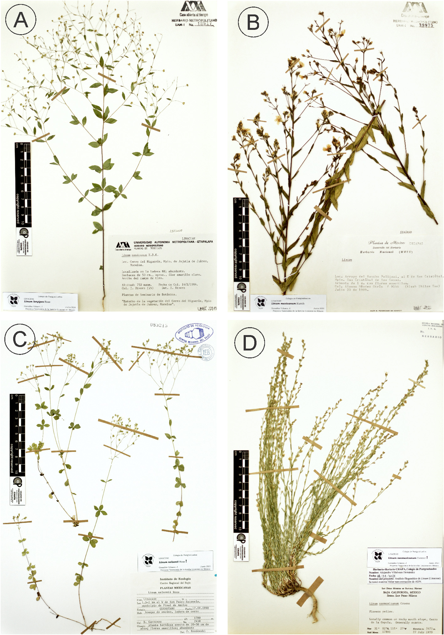
Linum nelsonii Rose (1906: 117) View in CoL ( Fig. 7c View FIGURE 7 ).
Type:— MEXICO. Veracruz : municipality of Orizaba, Boca del Monte , E. W. Nelson 210 ( Holotype: US!) .
Description: — Herbs, perennial, occasionally annual, 17–65 cm in height, glabrous or sparely pubescent, root thin; stems erect to decumbent, commonly unbranched up to the inflorescence, essentially glabrous. Leaves, basal entire or ciliated, arranged in whorls of 4–6; distal glandular-dentate, alternate or opposite, ovate to obovate; 4.0–18.0(– 21.0) × 2.0–12.0 mm, decreasing to the inflorescence, sessile, apex obtuse to rounded or acute in distal leaves; 3–5- nerved, central nerve prominent; smooth, glabrous or with scattered pubescence, stipular glands present at the base. Inflorescence a cymose panicle, pedicels 3.0–12.0 mm long, rarely pubescent, whitish hairs; bracts 3.5–10.0 mm long, margin denticulate, apex acuminate, stipular glands present at the base; sepals persistent, lanceolate to narrowly lanceolate or narrowly ovate, 2.5–4.0 × 1.0–2.0 mm, margin glandular-dentate, apex acute to acuminate; 1–(3)-nerved, central nerve prominent; sparsely pubescent, occasionally with stipular glands present at the base; petals yellow-green, oblanceolate to obovate, 3.0–5.0 mm long, glabrous; stamens 2.0–4.0 mm long, villous at the base; anthers 0.6–1.0 mm long, light yellow; staminodia small; styles free, 1.7–4.0 mm long; stigmata capitate, yellow. Fruit widely ovoid, yellow, 1.4–2.0 × 1.5–2.0 mm, pericarp thin, apex acute pubescent, dehiscent into 10 segments, false septa partially developed, septa occasionally with marginal cilia; seeds oblong to ovate, reddish-brown, 0.8–1.3 × 0.5–0.7 mm.
Distribution: —In Mexico, in Chiapas, Coahuila, Guanajuato, Hidalgo, Nayarit, Nuevo Leon, Oaxaca, Puebla, Queretaro, San Luis Potosi, Tamaulipas, and Veracruz ( Fig. 2b View FIGURE 2 ); to Guatemala, Honduras, and Nicaragua.
Habitat and ecology: —Deciduous forest, cypress-juniper forest, oak forests, oak-pine forests, chaparral shrubland, mangrove forest, thorny shrubland, thornless or sub-thornless small-leaved shrubland, pine forests, low deciduous tropical forest, medium or low evergreen tropical forest. Elevation 550–2400 m.Andosol,Acrisol, Cambisol, Phaeozem, Lithosol, Luvisol, Regosol, Rendzina, Vertisol, and Xerosol soil types.
Phenology: —Flowering in February–November; fruiting in April–November.
Note: —According to Rzedowski & Calderón de Rzedowski (1994), the type locality is probably in the state of Puebla. Although L. nelsonii is frequently confused with L. schiedeanum , L. nelsonii can be consistently differentiated from the latter by its pubescent pedicels and stipular glands present at the base of bracts and occasionally in sepals.
Conservation status: —Although according to the criterion B2 established by the IUCN (2019), L. nelsonii can be considered as endangered because of presenting an AOO of 80 km 2, its EOO ( 496,346.970 km 2) exceeds the value necessary for a threatened category. Therefore, this species is LC given its wide distribution and number of known localities inside and outside the country.
Specimens examined: — MEXICO. Chiapas: Comitán, km17, carretera Comitán, 3 Lagunas , 1781 m, 16°17’39”N, 92°15’59”W, 2 September 2008, G. López V. 1230 ( XAL!) GoogleMaps ; Oxchuc, Tz´unun , a 3 km de la escuela por el lado sur, 2400 m, 13 March 1988, F. Gómez S. 19 ( MEXU!) ; Oxchuc , 8 km al norte de Oxchuc, 2400 m, 12 May 1988, F. Gómez S. 164 ( MEXU!) . Coahuila: Castaños, Sierra La Gavia , 1295 m, 26°10’00”N, 101°18’00”W, 10 August 1995, M.A. Carranza y J. Encinas 2261 ( ANSM!) GoogleMaps ; Castaños, Sierra La Gavia , 1500 m, 26°10’00”N, 101°18’00”W, 25 October 1995, J.A. Villarreal & M.A. Carranza 8363 ( ANSM!) GoogleMaps ; Ramos Arizpe, Sierra de La Paila , 1600 m, 25°58’00”N, 101°32’00”W, 2 November 1988, J.A. Villarreal et al. 4739 ( ANSM!) GoogleMaps . Guanajuato: San Luis de la Paz, La Ventana, cerca de Mesas de Jesús , 2000 m, 24 March 1990, E. Ventura & E. López 7837 ( XAL!) . Hidalgo: Molango , 5-6 km al N de Ismolintla, 1900 m, 20°46’37.23”N, 98°43’59.95”W, 27 April 1981, R. Hernández et al. 5893 ( MEXU!) GoogleMaps . Nayarit: Tepíc, 5 km de la desviación al Rancho La Noria , 1500 m, 21°29’00”N, 104°59’00”W, J.I. Calzada et al. 19192 ( XAL!) GoogleMaps . Puebla: Oriental, Zautla , 2000 m, 6 August 1986, F. Ventura A. 22272 ( XAL!) . Nuevo Leon: Galeana, Ca. 13 miles SW of Galeana, 2200 m, 24°43’00”N, 100°12’00”W, 10 September 1999, Henrickson & V. Heuvel 22472B ( ANSM!) GoogleMaps ; Santiago, Cola de Caballo , 9 May 1979, J.A. Villarreal 2463 ( ANSM!) . Oaxaca: Eloxotitlán de Flores Magón, Alrededores del Puente de Fierro , 1175 m, 18°09’11.8”N, 96°51’11.7”W, 9 March 2001, Munn-Estrada et al. 856 ( TEX!) GoogleMaps . Queretaro: Arroyo Seco, 6 km al E de la Florida , 1260 m, 21°25’48”N, 99°42’06”W, 13 April 2007, S. Zamudio et al. 13698 ( IEB!) GoogleMaps ; Jalpan de Serra, 4-5 km al SE de San Juan de los Durán , 1850 m, 24 May 2012, E. Carranza G. 7670 ( ANSM!) ; Jalpan de Serra, Cañada en la ladera O del Cerro Grande , 2110 m, 21°25’56”N, 99°08’46”W, 29 March 2012, G. Aguilar-Gutiérrez et al. 854 (IEB!, XAL!) GoogleMaps ; Jalpan de Serra , 4-5 km al sur de La Parada, 1200 m, 18 December 1991, B. Servín 1481 ( IEB!) ; Jalpan de Serra , 2-3 km al poniente de El Saucito, 900 m, 13 March 1991, B. Servín 882 ( IEB!) ; Landa , 2 km al S de El Rincón, 900 m, 2 April 1987, Rzedowski 42916 ( XAL!) ; Pinal de Amoles , 2 km al S de San Pedro Escanela, 1740 m, 22 February 1991, E. Carranza 3035 ( IEB!) ; Pinal de Amoles , 1.5-2 km al W de San Pedro Escanela, 1780 m, 17 April 1990, E. Carranza 2438 ( IEB!) ; Pinal de Amoles, Cerca de Huazmazontla , 1300 m, 12 March 1989, Rzedowski 48399 ( XAL!) . San Luis Potosi: El Naranjo, Vicinity El Salto above El Naranjo , 446 m, 22°35’11.79”N, 99°23’0.59”W, 1 April 1960, J.A. Duke 3675 ( MEXU!) GoogleMaps . Sinaloa: Concordia , 4.5 km al SE de La Petaca, 1700 m, 12 February 2000, R. Vega-Aviña & J.A. Gutiérrez-García 10554 ( MEXU!) . Tamaulipas: Hidalgo, Into the Sierra 14.9 mi W of Hotel Santa Engracia, 570 m, 24°01’00”N, 99°34’00”W, 17 April 1988, G. Nesom 6339 ( XAL!) GoogleMaps . Veracruz: Huiloapan, Cerro de San Cristóbal , 1300 m, 18°48’00”N, 97°03’00”W, 22 April 1982, J.I. Calzada 8592 ( XAL!) GoogleMaps .

| XAL |
Instituto de Ecología, A.C. |
| MEXU |
Universidad Nacional Autónoma de México |
| ANSM |
Universidad Autónoma Agraria Antonio Narro |
| TEX |
University of Texas at Austin |
| IEB |
Instituto de Ecología, A.C. |
No known copyright restrictions apply. See Agosti, D., Egloff, W., 2009. Taxonomic information exchange and copyright: the Plazi approach. BMC Research Notes 2009, 2:53 for further explanation.
|
Kingdom |
|
|
Phylum |
|
|
Class |
|
|
Order |
|
|
Family |
|
|
Genus |
Linum nelsonii Rose (1906: 117)
| González-Velasco, Juan, Burgos-Hernández, Mireya, Galván-Escobedo, Iris G. & Castillo-Campos, Gonzalo 2022 |
Linum nelsonii
| Rose, J. N. 1906: ) |