
Tylodinus pusillus Luna-Cozar, 2014
|
publication ID |
https://doi.org/10.11646/zootaxa.3788.1 |
|
publication LSID |
lsid:zoobank.org:pub:7484832A-025B-41FA-9696-DF7531C01AA4 |
|
DOI |
https://doi.org/10.5281/zenodo.5080180 |
|
persistent identifier |
https://treatment.plazi.org/id/C27E87FF-FFB3-6125-FF14-DBAA2584FB2E |
|
treatment provided by |
Felipe |
|
scientific name |
Tylodinus pusillus Luna-Cozar |
| status |
sp. nov. |
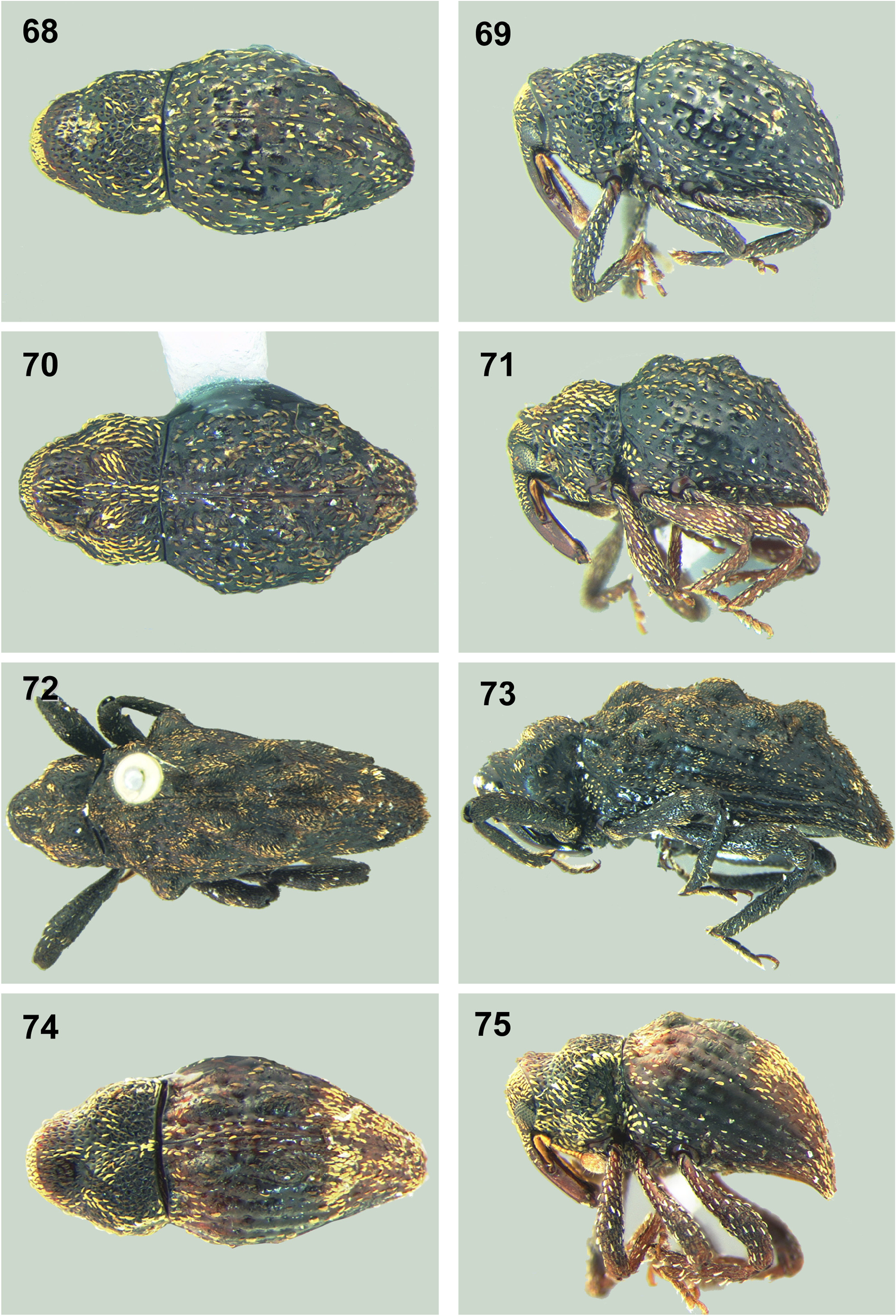
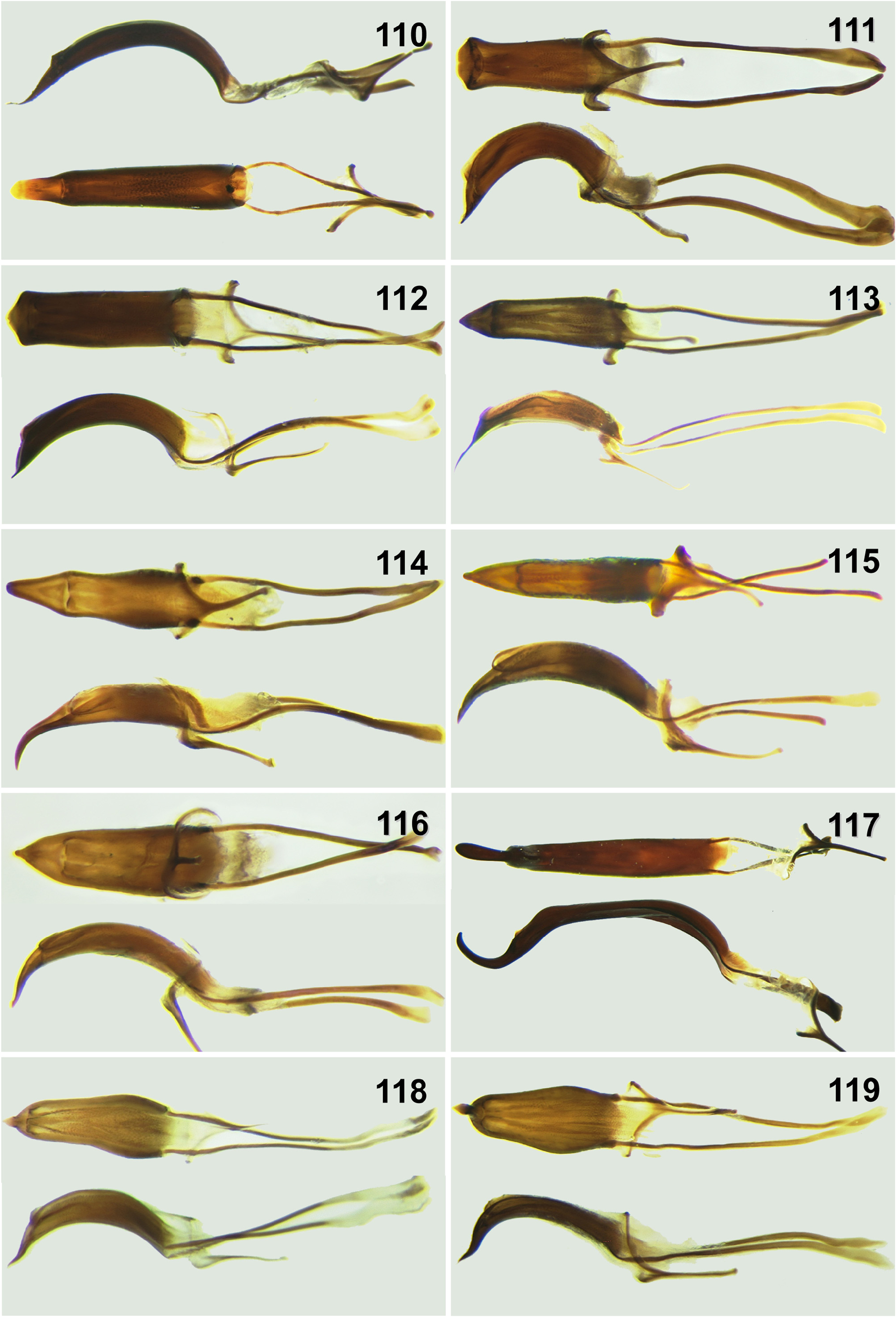
22. Tylodinus pusillus Luna-Cozar , sp. nov.
( Figures 68–69 View FIGURES 68–75 , 115 View FIGURES 110–119 , 133 View FIGURES 132–133 )
Diagnosis. Length male 1.8-2.3 mm, female, 1.8-2.2 mm. Width male 0.9-1.0 mm, female, 1.0- 1.1 mm. Body 2.1x longer than wide, cuticle shiny, scales pale yellow. Pronotum somewhat hollowed. Base of elytra declivity with tubercle on I2 longer than tubercle on I4. Abdomen with ventrite 2 longer than ventrites 3-4 combined. Legs black, femora unarmed, occasionally with moderately to distinctly obtusely angulate carina. Male genitalia ( Figure 115 View FIGURES 110–119 ) with median lobe in lateral view stout; in ventral view as long as apodemes, lateral sides subparallel. Female genitalia with sternite eight trapezoidal, with median membranous area along the basal plate, ramus and nodulus indistinct.
Geographic distribution. México ( Chiapas).
Habitat and elevation. Specimens were collected from leaf litter in high elevation cloud forest between 1800- 2200 m.
Derivation of specific name. Name derived from Latin word pusillus = tiny, wee, very small.
Material examined. Total 83 males, 62 females. Holotype male ( CMNC): México: 4.3 Km SE Custepec, Campamento El Quetzal , elev. 2160 m ( 15°42'N, 92°56’W), 18.vii.2007, coll. M. G. Branstetter (#679). GoogleMaps Paratypes: México: Chiapas, 4km SE Custepec, elev. 2140 m ( 15.70954°N 92.92916°W), 20.v.2008, coll. LLAMA (Wa-A- 03-1-41) GoogleMaps — 1 male, 1 female ( CMNC); Ángel Albino Corzo, Reserva El Triunfo, Campamento , elev. 2020 m ( 15°39'25.6''N, 92°48'40.3''W), 16-20.xi.2002, coll. R GoogleMaps . Jones — 1 male ( CMNC); La Concordia , 4 km SE Custepec, elev. 2125 m ( 15.70777°N 92.93110°W), 20.v.2008, coll. LLAMA (Wa-A-03-2-01) GoogleMaps — 1 male ( CMNC); 4.3 Km SE Custepec, Campamento El Quetzal , elev. 2160 m ( 15°42'N, 92°55'59.9''W), 17.vii.2007, coll. M. G. Branstetter — 3 females ( CMNC); same locality, 18.vii.2007, coll. M. G. Branstetter — GoogleMaps 3 males, 4 females ( BMNH, CMNC); 4 km SE Custepec, elev. 2125 m ( 15.70760°N 92.93115°W), 20.v.2008, coll. LLAMA (Wa-A-03-2-05) GoogleMaps — 1 male, 1 female ( CMNC); same locality ( 15.70764°N 92.93114°W), 20.v.2008, coll. LLAMA (Wa-A-03-2-04) GoogleMaps — 3 males ( CMNC); same locality ( 15.70755°N 92.93116°W), 20.v.2008, coll. LLAMA (Wa-A-03-2-06) GoogleMaps — 1 male ( CMNC); same locality ( 15.70746°N 92.93118°W), 20.v.2008, coll. LLAMA (Wa-A-03-2-08) GoogleMaps — 1 male ( CMNC); 4 km SE Custepec , elev. 2125 m ( 15.70721°N 92.93127°W), 20.v.208, coll. LLAMA (Wa-A-03-2-14) GoogleMaps — 1 male, 1 female ( ECOS); same locality ( 15.71119°N 92.92840°W), 20.v.2008, coll. LLAMA (Wa-A-03-1-01) GoogleMaps — 3 males, 1 female ( ECOS); same locality ( 15.71115°N 92.92842°W), 20.v.2008, coll. LLAMA (Wa-A-03-1-02) GoogleMaps — 1 male ( ECOS); same locality ( 15.71111°N 92.92844°W), 20.v.2008, coll. LLAMA (Wa-A-03-1-03) GoogleMaps — 1 male ( CMNC); same locality ( 15.71078°N 92.92859°W), 20.v.2008, coll. LLAMA (Wa-A-03-1-11) GoogleMaps — 2 females ( CMNC); same locality ( 15.71032°N 92.92880°W), 20.v.2008, coll. LLAMA (Wa-A-03-1-22) GoogleMaps — 1 male ( ECOS); same locality ( 15.71028°N 92.92882°W), 20.v.2008, coll. LLAMA (Wa-A-03-1-23) GoogleMaps — 1 male, 3 females ( CMNC); same locality ( 15.70941°N 92.92922°W), 20.v.2008, coll. LLAMA (Wa-A-03-1-44) GoogleMaps — 1 males, 2 females ( ECOS); same locality ( 15.71024°N 92.92884°W), 20.v.2008, coll. LLAMA (Wa-A-03-1-24) GoogleMaps — 1 female ( CMNC); same locality ( 15.70950°N 92.92918°W), 20.v.2008, coll. LLAMA (Wa-A-03-1-42) GoogleMaps — 1 female ( CMNC); same locality ( 15.71016°N 92.92887°W), 20.v.2008, coll. LLAMA (Wa-A-03-1-26) GoogleMaps — 1 female ( CMNC); same locality ( 15.70937°N 92.92924°W), 20.v.2008, coll. LLAMA (Wa-A-03-1-45) GoogleMaps — 2 males, 2 females ( ECOS); same locality ( 15.70933°N 92.92925°W), 20.v.2008, coll. LLAMA (Wa-A-03-1-46) GoogleMaps — 1 female ( CMNC); same locality ( 15.70929°N 92.92927°W), 20.v.2008, coll. LLAMA (Wa-A-03-1-47) GoogleMaps — 2 males, 1 female ( CMNC); same locality ( 15.70925°N 92.92929°W), 20.v.2008, coll. LLAMA (Wa-A-03-1-48) GoogleMaps — 3 males, 5 females ( BMNH, CMNC, CWOB); same locality ( 15.70917°N 92.92933°W), 20.v.2008, coll. LLAMA (Wa-A-03-1-50) GoogleMaps — 1 male, 1 female ( ECOS); same locality ( 15.70777°N 92.93110°W), 20.v.2008, coll. LLAMA (Wa-A-03-2-01) GoogleMaps — 1 male, 1 female ( CMNC); same locality ( 15.70773°N 92.93111°W), 20.v.2008, coll. LLAMA (Wa-A-03-2-02) GoogleMaps — 1 female ( CMNC); same locality ( 15.70742°N 92.93120°W), 20.v.2008, coll. LLAMA (Wa-A-03-2-09) GoogleMaps — 1 male, 1 female ( CMNC); same locality ( 15.70729°N 92.93123°W), 20.v.2008, coll. LLAMA (Wa-A-03-2-12) GoogleMaps — 1 male, 2 females ( ECOS); same locality ( 15.70725°N 92.93125°W), 20.v.2008, coll. LLAMA (Wa-A-03-2-13) GoogleMaps — 1 female ( CMNC); same locality ( 15.70708°N 92.93131°W), 20.v.2008, coll. LLAMA (Wa-A-03-2-17) GoogleMaps — 1 female ( CMNC); same locality ( 15.70662°N 92.93126°W), 20.v.2008, coll. LLAMA (Wa-A-03-2-28) GoogleMaps — 1 male, 1 female ( ECOS); same locality ( 15.70658°N 92.93126°W), 20.v.2008, coll. LLAMA (Wa-A-03-2-29) GoogleMaps — 1 male, 2 females ( ECOS); same locality ( 15.70644°N 92.93124°W), 20.v.2008, coll. LLAMA (Wa-A-03-2-32) GoogleMaps — 1 female ( CMNC); same locality ( 15.70635°N 92.93125°W), 20.v.2008, coll. LLAMA (Wa-A-03-2-34) GoogleMaps — 1 male, 1 female ( CMNC); same locality ( 15.70631°N 92.93126°W), 20.v.2008, coll. LLAMA (Wa-A-03-2-35) GoogleMaps — 1 male, 2 females ( CMNC); same locality ( 15.70595°N 92.93129°W), 20.v.2008, coll. LLAMA (Wa-A-03-2-43) GoogleMaps — 5 males, 4 females ( CMNC, ECOS); same locality ( 15.70591°N 92.93129°W), 20.v.2008, coll. LLAMA (Wa-A-03-2-44) GoogleMaps — 2 females ( CMNC); same locality ( 15.70568°N 92.93128°W), 20.v.2008, coll. LLAMA (Wa-A-03-2-49) GoogleMaps — 1 female ( CMNC); same locality, elev. 2140 m ( 15.71065°N 92.92865°W), 20.v.2008, coll. LLAMA (Wa-A-03-1-14) GoogleMaps — 1 male ( CMNC); same locality ( 15.70987°N 92.92901°W), 20.v.2008, coll. LLAMA (Wa-A-03-1-33) GoogleMaps — 1 male ( CMNC); same locality ( 15.70983°N 92.92903°W), 20.v.2008, coll. LLAMA (Wa-A-03-1-34) GoogleMaps — 1 male ( CMNC); same locality ( 15.70970°N 92.92908°W), 20.v.2008, coll. LLAMA (Wa-A-03-1-37) GoogleMaps — 3 males ( ECOS); same locality ( 15.70962°N 92.92912°W), 20.v.2008, coll. LLAMA (Wa-A-03-1-39) GoogleMaps — 2 males ( ECOS); same locality ( 15.70946°N 92.92920°W), 20.v.2008, coll. LLAMA (Wa-A-03-1-43) GoogleMaps — 1 male ( CMNC); same locality, elev. 2125 m ( 15.70738°N 92.93121°W), 20.v.2008, coll. LLAMA (Wa-A-03-2-10) GoogleMaps — 1 male ( CMNC); same locality ( 15.70733°N 92.93122°W), 20.v.2008, coll. LLAMA (Wa-A-03-2-11) GoogleMaps — 1 male ( CMNC); same locality ( 15.70682°N 92.93136°W), 20.v.2008, coll. LLAMA (Wa-A-03-2-23) GoogleMaps — 1 male ( CMNC); same locality ( 15.70679°N 92.93133°W), 20.v.2008, coll. LLAMA (Wa-A-03-2-24) GoogleMaps — 1 male ( CMNC); same locality ( 15.70667°N 92.93127°W), 20.v.2008, coll. LLAMA (Wa-A-03-2-27) GoogleMaps — 2 males ( CMNC); same locality ( 15.70653°N 92.93125°W), 20.v.2008, coll. LLAMA (Wa-A-03-2-30) GoogleMaps — 1 male ( CMNC); same locality ( 15.70618°N 92.93128°W), 20.v.2008, coll. LLAMA (Wa-A-03-2-38) GoogleMaps — 1 male ( ECOS); same locality ( 15.70609°N 92.93129°W), 20.v.2008, coll. LLAMA (Wa-A-03-2-40) GoogleMaps — 1 male ( ECOS); same locality ( 15.70600°N 92.93130°W), 20.v.2008, coll. LLAMA (Wa-A-03-2-42) GoogleMaps — 1 male ( CMNC); same locality ( 15.70582°N 92.93128°W), 20.v.2008, coll. LLAMA (Wa-A-03-2-46) GoogleMaps — 2 males ( CMNC); Reserva de la Biósfera El Triunfo, Campamento El Quetzal , elev. 2160 m ( 15°42'18.4''N, 92°55'53.8''W), 22.v.2008, coll. R GoogleMaps . S. Anderson — 1 male ( CMNC); Reserva de la Biósfera El Triunfo, Campamento El Quetzal , elev. 1800 m ( 15°43'14.5''N, 92°56'24.4''W), 18.vii.2007, coll. R GoogleMaps . S. Anderson — 1 male ( CMNC); same locality, elev. 2200 m ( 15.70819°N 92.93070°W)— GoogleMaps 2 males ( CMNC); same locality, elev. 2160 m ( 15.70510N 92.93157W)— 1 male ( CMNC); same locality, 21.v.2008, coll. R GoogleMaps . S. Anderson — 2 males ( CMNC); same locality, elev. 2180 m ( 15.71115°N 92.92832°W), 21.v.2008, coll. R GoogleMaps . S. Anderson — 3 females ( CMNC); same locality, 21.v.2008, coll. R GoogleMaps . S. Anderson — 2 males ( CMNC); Chiapas, Motozintla , 7 km SSW Motozintla de Mendoza, elev. 2000 m ( 15°19'40.8''N, 92°16'34.7''W), 17.ix.1992, coll. R GoogleMaps . S. Anderson — 2 females ( CMNC); Unión Juárez, Volcán Tacaná, lower slopes, ca 4 km N, Unión Juárez , elev. 2000 m ( 15°5'47.4''N, 92°5'17.2''W), 18.ix.1992, coll. R GoogleMaps . S. Anderson — 1 male, 1 female ( CMNC); same locality, 19.ix.1992, coll. R GoogleMaps . S. Anderson — 10 males, 4 females ( CMNC, CWOB, ECOS) .

| R |
Departamento de Geologia, Universidad de Chile |
No known copyright restrictions apply. See Agosti, D., Egloff, W., 2009. Taxonomic information exchange and copyright: the Plazi approach. BMC Research Notes 2009, 2:53 for further explanation.
|
Kingdom |
|
|
Phylum |
|
|
Class |
|
|
Order |
|
|
Family |
|
|
Genus |