
Tylodinus sepulturaensis Luna-Cozar, 2014
|
publication ID |
https://doi.org/10.11646/zootaxa.3788.1 |
|
publication LSID |
lsid:zoobank.org:pub:7484832A-025B-41FA-9696-DF7531C01AA4 |
|
DOI |
https://doi.org/10.5281/zenodo.5080168 |
|
persistent identifier |
https://treatment.plazi.org/id/C27E87FF-FFBB-612C-FF14-D95E20D4FA79 |
|
treatment provided by |
Felipe |
|
scientific name |
Tylodinus sepulturaensis Luna-Cozar |
| status |
sp. nov. |
17. Tylodinus sepulturaensis Luna-Cozar , sp. nov.
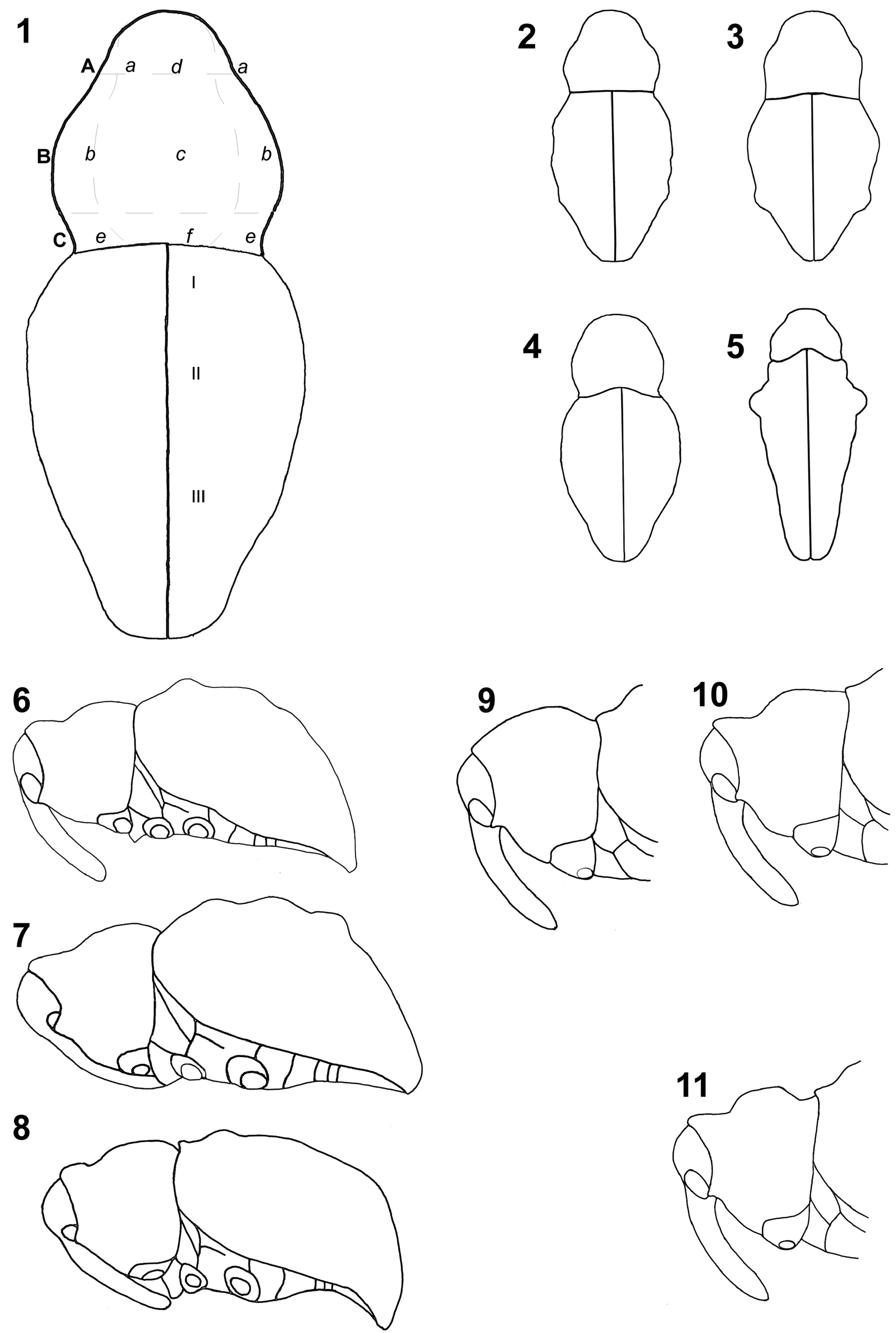
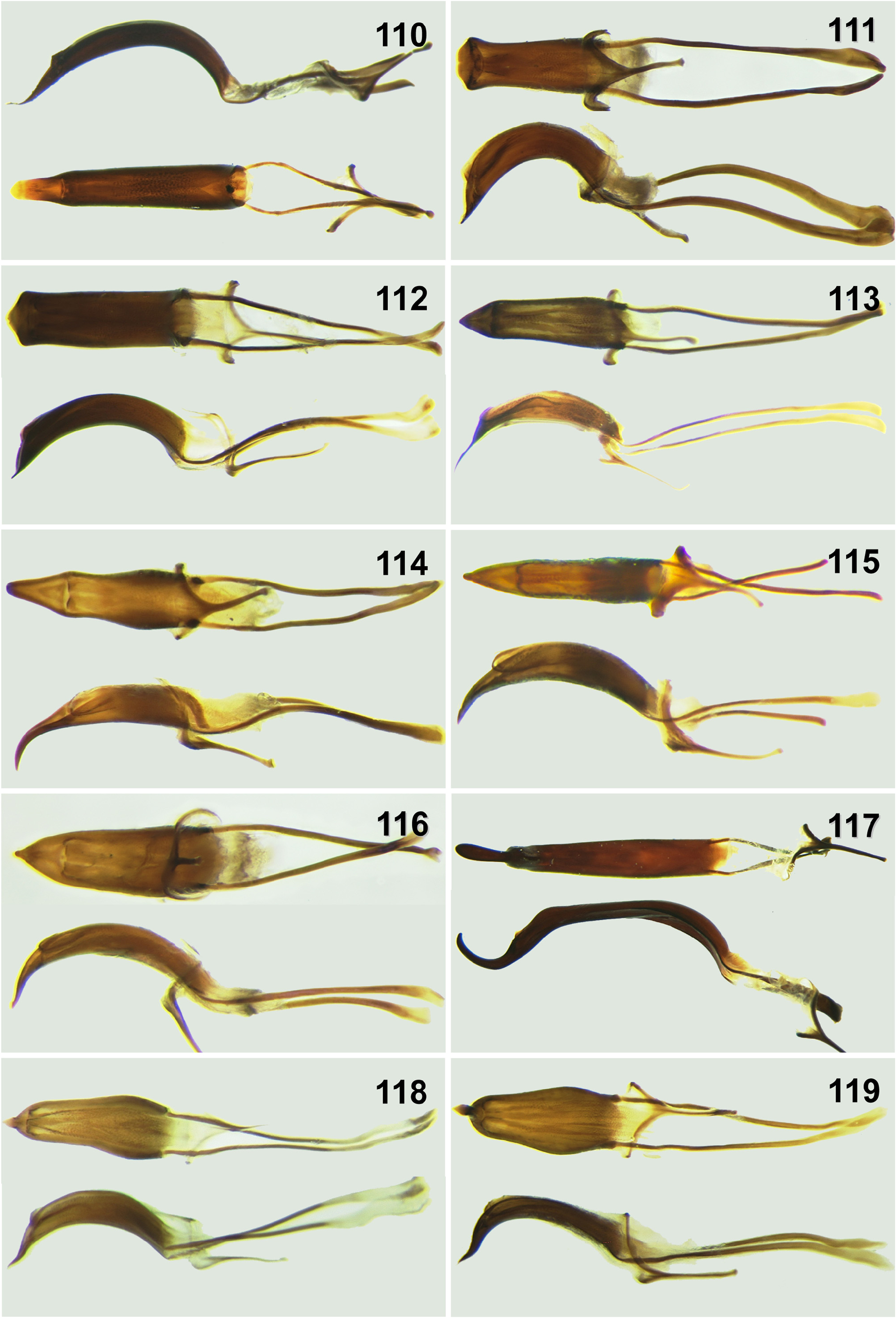
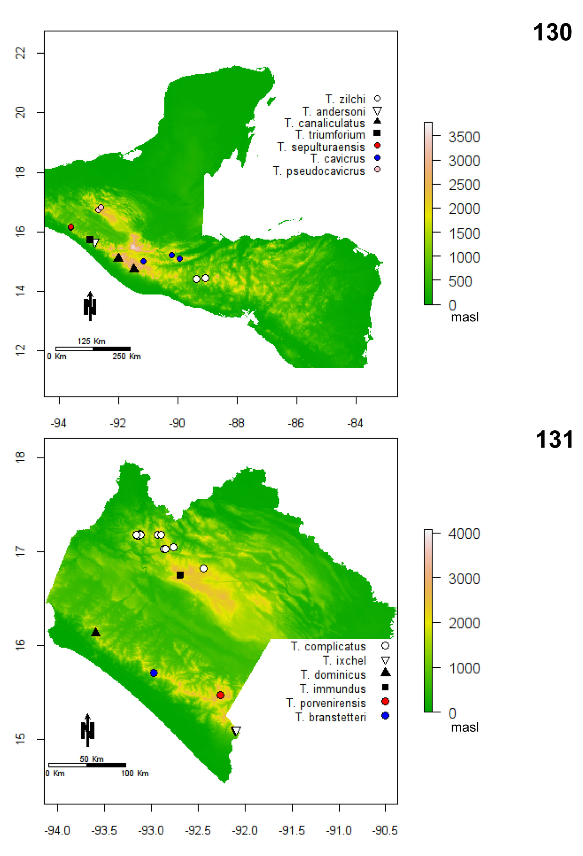
( Figures 10 View FIGURES 1–11. 1–5 , 58–59 View FIGURES 52–59 , 110 View FIGURES 110–119 , 130 View FIGURES 130–131 )
Diagnosis. Length male, 4.2–4.5 mm, female, 4.0– 4.5 mm. Width male, 2.1–2.3 mm, female 2.0– 2.3 mm. As for T. triumforium , with the follow exceptions: body approximately 2.1x longer than wide. Elytra without light scales on tubercles. Male genitalia ( Figure 110 View FIGURES 110–119 ) with apical process in ventral view longer. Female genitalia with median membranous area of sternite eight 2/3 as long as basal plate, spermatheca very shallowly curved.
Geographic distribution. México ( Chiapas).
Habitat and elevation. Specimens were collected from leaf litter in oak and cloud forest between 1300–1400 m.
Derivation of specific name. Name derived from the Latin word sepulturaensis = grave, sepulture, and La Sepultura, the name of the protected natural area where the species was collected.
Material examined. Total 7 males, 4 female. Holotype male ( CMNC): México: Chiapas, Villa Corzo , Ejido Sierra Morena, Reserva de la Biósfera La Sepultura, ( 16° 09' N, 93° 36'28.5"W), elev. 1372 m, 14.vii.2007. J.L. Cozar, hojarasca. Paratypes: México: Chiapas, Villa Corso, Ejido Sierra Morena, R GoogleMaps . Biosfera La Sepultura , elev. 1300 m ( 16°9'21.2''N, 93°36'2.9''W), 17.vii.2007, coll. R GoogleMaps . S. Anderson — 1 female ( CMNC); same locality, elev. 1367 m ( 16.16121°N, 93.60024°W), 12.v.2008, coll. R GoogleMaps . S. Anderson — 1 male, 1 female ( CMNC); same locality, 1348 m, ( 16°09.620’N 93°36.343’W), 12.v.2008, coll. R GoogleMaps . S. Anderson — 1 male ( CMNC); Villa Flores, Sierra Morena , elev. 1390 m ( 16°9'22.7'' N, 93°35'57.1'' W), 24.vi.2006, coll. J. L. Cozar — GoogleMaps 1 male ( ECOS); same locality, elev. 1360 m ( 16.16036°N, 93.60511°W), 12.v.2008, LLAMA (Wa-A-01-1-42) GoogleMaps — 1 male ( ECOS); same locality, elev. 1330 m ( 16.15282°N, 93.60067°W), 12.v.2008, LLAMA (Wa-A-01-2-39) GoogleMaps — 1 male ( CMNC); same locality, elev. 1330 m ( 16.15296°N, 93.60042°W), 12.v.2008, LLAMA (Wa-A-01-2-45) GoogleMaps — 1 female ( CMNC); same locality, elev. 1310 m ( 16.15453°N, 93.60080°W), 12.v.2008, LLAMA (Wa-A-01-2-06) GoogleMaps — 1 female ( ECOS); same locality, elev. 1360 m ( 16.15948°N, 93.60516°W), 12.v.2008, LLAMA (Wa-A-01-1-04) GoogleMaps — 1 male ( CMNC) ;

| R |
Departamento de Geologia, Universidad de Chile |
No known copyright restrictions apply. See Agosti, D., Egloff, W., 2009. Taxonomic information exchange and copyright: the Plazi approach. BMC Research Notes 2009, 2:53 for further explanation.
|
Kingdom |
|
|
Phylum |
|
|
Class |
|
|
Order |
|
|
Family |
|
|
Genus |